Tuesday, May 17, 2016

Mt Shannon, Goat Pasture Hill & Pine Mountain

Today was a much more successful outing mentally than last week. I belong to a group on Facebook called 'Belknap Range Hikers' which has been a great resource as many fellow hikers post about their own adventures with pictures and trip reports. As you know I like to research as much as I can before heading out on new trails. Just gives me that sense of peace to have a clue what I'm doing! (well at least convince myself that I do). So today I met up with a new friend, Tracy from Hooksett, who also belongs to the FB group and has been working on her redlining as well. We met up at the Hidden Valley Scout Camp and briefly introduced ourselves before heading off.. in the opposite direction than I went last week. I was now going to complete the Mt Shannon/Goat Pasture Hill area. We headed up towards Sunset Lake on the Red/Yellow trail, which separated once we reached the lake. We took Yellow just over half a mile to the summit of Mt Shannon. Felt much better than when I was there not even a week ago.. still lots of annoying black flies, but I was a little more prepared this time with long sleeves which definitely helped a lot. They were still annoying around our faces, but nowhere near as bad as last week. No matter how many times I visit a summit, I'm going to take a picture. It is never the same. So I like to remember that moment in time, even if I experience it 1000 times over! Summit shots taken we headed down the Blue/Yellow trail and then Blue Trail to Old Stage Road. This section that seemed neverending last week when I battled mental fatigue felt so quick today. Having a buddy to talk to makes all the difference in the world! We turned onto Old Stage Road and headed down to the intersection with the Anna-Goat Pasture Hill Trail. We passed the ladies from earlier as they were heading in the opposite direction to us and reached the red blazes. Funny thing is, having just come down the northern part of this trail a few weeks ago with Vanessa, I knew the trail continued on over Old Stage Road and even commented that I wondered where, as we didn't spot any additional red blazes.. but there they were. Definitely didn't look like a trail as it was rather overgrown at first, but the blazes on the trees were obvious enough if you were looking for them! There were a couple of steep little climbs (at least I thought) for a small peak, and we actually didn't even really realize we had passed over the summit.. although we inadvertently had stopped for a break/picture opportunity and to reapply bug spray, without realizing that was the summit. Once over Goat Pasture Hill and heading back down, we met up with the other end of the Blue Trail and took the quick 0.2 mile trip up the one section of Blue we had yet to complete. That was a nice little section following a brook for most of the way. Back on Red and over the brook, the trail flattened considerably and was really quite enjoyable. It made its way back over to Sunset Lake with a lovely vista alongside a firepit and then followed the edge of the lake back for about 0.5 miles to the Scout Camp. We ended up with right around 6 miles for the day. Although we had been out for 3 hours, it really went by fast and was a very enjoyable morning. Tracy and I parted ways and I headed over to Pine Mountain on Alton Mountain Road. I had hiked this mountain 2 years ago, long before learning of the redlining patch and I've since discovered there is another trail on the opposite side than where we had been that I needed to explore. I had been passing the trailhead each time driving to Camp Bell and Hidden Valley and kept thinking "I should just stop and do this one of these days on the way back".. today, was the day. I'm not sure you are supposed to park where I did, so I parked with care not to block the gate. The trail is essentially an old jeep road, in pretty good condition. The ascent is gradual but my legs felt a bit tired from the earlier hike. The view is pretty stunning from this little mountain. Not only does it look over Lake Winnipesaukee, there is a great view over the Belknaps, the Ossipees and the White Mountains beyond. On a clear day like I had today it is really quite spectacular. I could have stood and just taken it all in for hours. The breeze kept the bugs away. Pretty much perfect. I had spotted a really large boulder on my way up and on the way back saw a herd path leading over to it, so I decided to go check it out.. and found the geographical benchmark is actually atop the boulder! I tried from several different angles to climb up the boulder, but it was just sheer enough and without any real footholds, that I couldn't do it.. even with the small rock step someone had placed alongside. I just wasn't quite tall enough. So I reached up with the camera as best I could to snap a shot of the benchmark and headed back down to the car. Having the view in front of you on the way down is extra amazing. A really beautiful area. I passed a couple walking their dogs near the bottom of the trail, they must live in the area as there were no other cars when I got back. They also mentioned the black flies, so ordinarily there must be a lot on the trail or at the summit. So glad that wasn't the case today! Another successful day in the Belknaps.


Mt Shannon and Goat Pasture Hill

Pine Mountain


Start of the Red/Yellow trail behind Hidden Valley Scout Camp

Intersection of Yellow and Red trails at Sunset Lake

Mt Shannon summit


descending Mt Shannon

The start of Anna-Goat Pasture Hill Trail South from Old Stage Road

What we think was the Goat Pasture Hill summit

Intersection of Red and Blue trails

Intersection of Red and Blue trail

we took the 0.2 miles back to complete the Blue Trail

Brook crossing on the Red Trail


Sunset Lake from the Red Trail

Sunset Lake from the Red Trail


Trail gate for Mary Jane Morse Greenwood Trail to Pine Mountain

Trees like this always make me think of an art sculpture

Mary Jane Morse Greenwood Trail to Pine Mountain

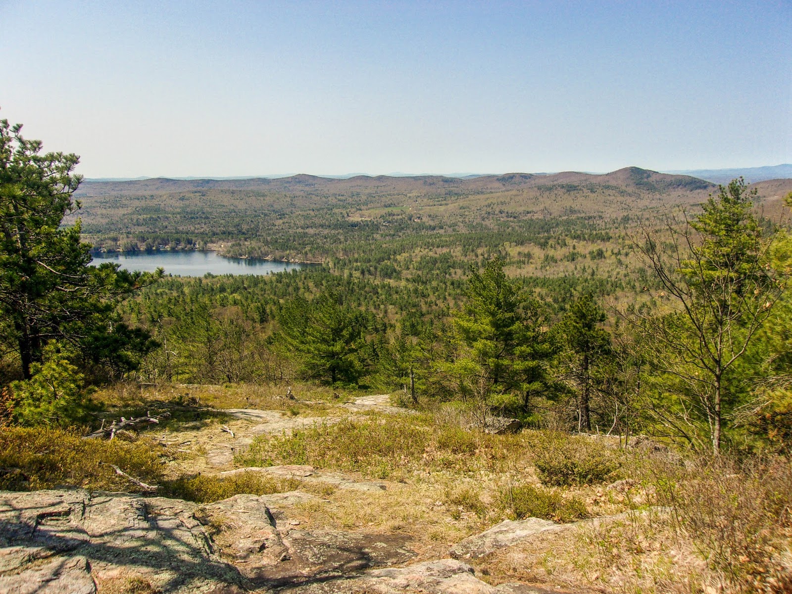
Pine Mountain view ledges


blurry benchmark atop a boulder on Pine Mountain

The boulder I could not get up

Another view of the boulder with the benchmark on top

Intersection of Mary Jane Morse Greenwood Trail and Robert Greenwood Sr Loop

Mary Jane Morse Greenwood Trail


Thursday, May 12, 2016

Mack, Anna & Shannon

The thing with redlining is, you often have to repeat peaks multiple times to cover all the trails in that area. I'm not an ultra-endurance hiker who can do miles and miles all in one go.. so multiple trips it is. Today I set out for 2 more trail completions towards my redlining patch. I had anticipated around 8 miles. Ended up being 9, which was fine.. but the journey was one of self doubt and a mental struggle to "just keep swimming". I parked at Hidden Valley Scout Camp which is a beautiful area in which the Scout administration allows hikers to utilize the area to access the trails. I knew there was roughly a 0.5 mile hike to reach the trailhead and I set out enjoying the scenery of Lake Eileen and the camp itself. I reached a fork and contemplated which way to go, while watching my Suunto expecting the trailhead at any moment. When it didn't arrive I kept thinking "just a little more, must be just up here".. when it still didn't arrive, I stopped, pulled out the map and tried to figure out where I had gone wrong. I had previously seen some blazes, so knew I had been on the right track.. I spotted a worker and asked him, but he had no clue, so I backtracked to find where the blazes had stopped.. and sure enough (and thankfully only 0.3 miles... which was 0.6 miles once I backtracked) I found the last blaze and there was the trailhead sign. Whoops! I had read it was well-marked, (which it is), but I was anticipating a larger sign I think and just waltzed right past this one the first time. So I headed off down the trail. During my pre-hike research, I had read the Mack Ridge Trail was better to ascend as there were some areas of steep rock to scramble up. I was grateful to have this knowledge as it certainly was a little steep in places, but nowhere near as bad as I had mentally prepared for. The Mack Ridge trail covers a variety of terrain from the rock scramble, to woods, to ledge.. the lower half is much "cleaner", I found the top half rather overgrown and messy. Easy to follow though. The worst part today were the bugs. I cannot express how awful the bugs were. I had sprayed bug spray, but stopped to reapply about 2 miles in. Just awful. There were some areas near the top where the breeze picked up slightly and kept them at bay, but overall it was just a buggy nightmare. I reached the intersection with the Round Pond-Mack Trail, which the boys and I hiked 2 weeks ago, this time staying on the Orange trail and finishing the 0.3 miles to the little campsite area we had lunched at previously. Thankfully this area was not so buggy (which made no sense as it's by the pond) and I stopped for my sandwich. Heading down to the pond I spotted my first snake of the year and as always jumped a mile and screamed. I hate snakes. Hate, hate, hate. Saw another one (or perhaps the same one) slither into the pond itself and swim away. So, I quickly packed myself up and headed back on the trail saying a small prayer that would be it in the reptile department for the day (it was.. Amen). Instead of backtracking the way I came, I made a little lollipop loop around the Red trail and Red/Orange trail and made my way up to Mt Mack. Even though I was just there 2 weeks ago, I snapped another quick summit picture and kept moving towards Mt Anna. This is where I started to really fatigue. I had to start really talking myself into taking each step. I am not sure what it was.. it was the first warm day of the season, and although I didn't feel hot, I don't know if that affected me. I had plenty of water and didn't make the same mistake I did last year on my Pemi attempt.. I drank even when I didn't feel thirsty. I had some orange energy chews, so I had a few of those and felt a little better. Made it over to Anna, took a quick summit picture and headed down my 2nd new trail of the day.. the Anna-Old Stage Road Trail. This started out a lovely hike with some pretty ledge views but quickly turned rather steep, made a little hairy by all the dry leaves on the trail. This slowed me right down. I'm always hesitant hiking in dry leaves. I slipped quite a few times and fell once when stepping on a patch of mud. It always seems to happen in slow motion too, as soon as I plant my foot my mind realizes what is happening and I see it all go down. No injuries and I was up and continuing. This trail is not as well used and was a little overgrown in places too. I became more tired and was just ready to be back at the car, but my plan was to ascend one more peak. I contemplated not doing this, but stuck it out with Plan A and once at Old Stage Road, continued on the Blue Trail heading for Mt Shannon. This trail was mostly flat with some up and down, which in my tired state just felt like forever. I fell again on some loose dry dirt this time and banged my elbow. I was mentally done by now. By the time I reached the final ascent to Mt Shannon, it was all I could do to keep going. I've hiked further distances and greater elevations, but it's always the mental challenge that gets me. I "felt" OK physically, I kept saying to myself "your legs don't hurt, you can't feel any blisters, suck it up buttercup".. I finished the last of my orange energy chews and slowly ascended what was probably 0.3-0.5 miles at most up to Mt Shannon. At the top were some really pretty, unexpected views back over the Scout Camp and Lake Eileen and a couple other smaller lakes I don't know the name of. A really, pretty spot. I often find these smaller, less known and less traveled peaks are just waiting for someone to find them so they can say "look at me, I'm beautiful too"! It was really buggy on Mt Shannon unfortunately, so I didn't linger. I could actually see my car from this summit, so my mojo was somewhat restored and I headed on down. Back at the car, I was able to look back up at the Mt Shannon summit and reflect on the day. It may have taken me longer than I had anticipated, but I did it. Body beat out mind. Now I just need to find some better bug spray and perhaps some bug resistant clothing... I am covered in black fly bites. I cannot believe how many I have, at least 2 dozen, and I didn't feel them biting me at all. Plus 2 ticks. The warm Winter and then long wait for Spring must have all these bugs just chomping at the bit to get their fill on us poor hikers! 

Strava Activity


The "elusive" trailhead

The road I was walking when I missed the above trailhead

Looking at the start of the trail from the road above

A little boulder field action on the Lower Mack Ridge Trail

Rockslide along the Lower Mack Ridge Trail

Looking up the Mack Ridge Trail


Some fun rock hopping along the Mack Ridge Trail

First viewpoint along Mack Ridge Trail


Lunch spot at Round Pond

Round Pond with Mt Belknap in the background


viewpoint along the Round Pond-Mack Trail

Mt Mack summit

Heading down the Mack-Anna (also Belknap Range Trail) towards Anna

water crossing on Mack-Anna Trail

Mt Anna summit


starting off down the Anna-Old Stage Road Trail


Blue Trail to Mt Shannon

viewpoint along Blue Trail to Mt Shannon

it's blurry.. I'm getting tired

Mt Shannon summit


there's my car.. Hallelujah.

Yep, I felt as bad as I look. Mt Shannon summit

Back at the car looking up to Mt Shannon