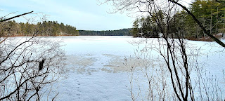
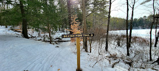
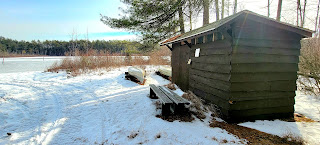
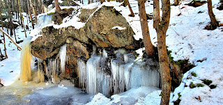
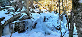
I had seen pictures of Pulpit Rock Conservation Area in Winter and wanted to go check it out. Knowing we have had some snow and freezing temperatures, I thought the waterfall/cascade areas might be pretty. I was right. After visiting Bridal Falls last year, I'm all about the frozen waterfalls. I had this area planned out into 2 hikes to complete all the trails and figured I'd do half now and the other half in the Spring once most of the snow has melted and hopefully the waterfalls/cascades are in full flow! I parked in the lot on New Boston Road, which I believe is the main lot for this area. I was the only car at 930am, which didn't surprise me with sub zero temperatures. Surprisingly the lot was full when I got back to the car around 1pm. I did pass several groups on my way out and was really surprised at how many people were not wearing traction on their footwear. I only saw a couple of people with spikes. While the trail was well packed down, it was quite icy in some sections and I found spikes necessary, especially down in the gorge. I will always do my best to be overly prepared. I started out on the Kennard Trail which was another lovely meander through the woods. Lots of low bridges covering areas that must see high water in season. Well maintained and well marked trails always make the day even more pleasant. At the first intersection, I took Campbell Trail, planning a loop around the gorge with a couple of out and backs per the map. Campbell Trail was slightly less traveled than Kennard, but was still packed down. I reached Scouting Way Trail and saw a CLOSED sign, however upon closer inspection underneath it said "Trail closed at other end" and there was evidence people had gone that way, so I figured I'd go as far as I could watching for any indication of where the trail was closed. I actually made it all the way to the road without seeing any signs. The previous footsteps became lighter and I figured it meant the trail was closed for parking access as it ended on a road in a neighborhood. The last couple tenths of this trail seemed very lightly used and I was glad for snow cover as it seemed to be rough with a lot of debris underneath. I imagine it's just locals of that neighborhood accessing via this path for the most part. At one point at a 90° turn there was a sign that said "Old Pulpit Farm Site", it seemed to be pointing up a little side path which was showing on my digital map, so I followed it, but it just ended in what looked like an orchard or something. Perhaps the farm remains were under the snow and I just didn't notice them as I passed by. Back on Campbell Trail, I was looking for Tufts Trail. I made it to the intersection with Ravine Trail and crossed a bridge. According to all the maps I had, Tufts Trail should have been right after this but for the life of me, I couldn't find it. I didn't want to venture too far down Pulpit Brook Trail looking for Tufts Trail as I didn't want to have to backtrack if I didn't find it. I could see very faded blazes and it looked like people had traveled where they went, so I thought that must be it. Started to follow but quickly reached a brook that didn't look easy to cross. Ice was thin and no rocks seemed visible for rock hopping. I heard and saw a couple with their dog on the other side, but they were further in, so I waited to see if they came down to the area I was so I could see where the trail was, but they didn't, so I figured I was not actually in the right place. I'm assuming the trail does actually begin further down Pulpit Brook Trail than I went, but I decided to take Ravine Trail instead. I had been concerned it would be too icy as I had read there were a couple steep sections, but figured I'd give it a shot. I'm really glad I did. The Ravine Trail follows the brook right up in the gorge under Pulpit Rock and was exactly what I had been hoping to see, which I wouldn't have if I'd taken my original route up Tufts Trail. All's well that ends well. There were definitely a couple sections that required some hand over hand crawling up due to the ice, but well placed roots and trees and faith in my spikes made all that doable. These sections were also very, very short. I couldn't stop taking pictures of all the frozen cascades, it was so pretty. I'm also glad I went in the direction I did, as I think it was easier going up those icy steep pitches, rather than down. Through the gorge and back up, I saw the other end of Tufts Trail, that will wait till I come back in Spring. There is a low bridge with a rope that I guess is to prevent you venturing too close to the edge and falling down into the gorge and a brief glimpse back down to where I was. I did a quick loop to finish off some short connector trails in that area and was back on Kennard Trail heading for the car. I did take the short off shoot to the campsite on the property and saw the tent platform and picnic table. I seem to have figured out layering, especially when there's no wind and stayed warm all day. A really wonderful day in a beautiful spot!
Strava Activity