Sunday, February 27, 2022

New London Conservation Commission - Webb Forest, Bunker Loop, Cocoa's Path

 Wanting a change of scenery... though honestly, wanders through the woods in Winter are fairly similar wherever you are.. I headed up to New London to check off a few more of the trails on the New London Conservation Commission list, which doubles as checkmarks on my AMC South  Trail Guide spreadsheet. We had a decent snowfall on Friday, so I wasn't sure what to expect. Parking on Lakeshore Drive, I crossed the road and met a runner who was just finishing up and she said snowshoes worked for her well. I had everything at the ready. At the kiosk I started in spikes as it looked fairly well packed down, and was on the initial ascent up Wolf Tree Trail to the intersection with Webb Forest Trail. These trails are all very well signed and marked with maps at each major intersection which is always helpful. Webb Forest Trail was less traveled but still broken out, probably should have used snowshoes, but I ascended in spikes. The trail has about 30 placards along the way explaining all the different types of trees and areas, which in Spring or Summer would likely be more useful than now with everything covered in snow! Moderate climb up a small hill, passing a lovely brook and a side path to an overlook.. that really didn't overlook anything. There were a couple large blowdowns along Webb Forest Trail, that required navigating around. I followed Webb Forest Trail up  and once at the top decided to change into snowshoes as I could see the path was even less traveled, though still broken out. This was a good decision and I made good time over the hill to the end, where it met up with Wolf Tree Trail again, right at an area that is currently being logged. No work being done today and there was decent signage to keep you on track. I picked up Bunker Loop which continued down and met up with Cocoa's Path. This also shares the same trail as Great Brook Trail, but I just did the section known as Cocoa's Path. This was really well packed, almost a bit icy, so I took off the snowshoes and just barebooted the rest of the way back to the car. This trail followed a lovely brook and several areas with small cascades as well as a pool area with a sign "Grampas Bathtub". It was a lovely ending to a bluebird day in the woods. 

Strava Activity


Webb Forest Trail merged with a road briefly, this was where it turned back into the woods


Blowdown along Webb Forest Trail


another blowdown on Webb Forest Trail


Logging area along Wolf Tree Trail

Trail turn at logging area on Wolf Tree Trail


Sunday, February 20, 2022

Fox State Forest West Side Trails

 Today was almost the complete opposite to yesterday. I revisited Fox State Forest in Hillsborough to start working on the West Side trails. I parked at the HQ parking and crossed Center St to access the trails. I started on Ridge Trail, which right away was in a logged area and was rather messy. Thankfully unlike yesterday, very well blazed and I had solid snow cover so much of the debris was covered and smoothed over, making easy going. Once on Hurricane Road, I followed to the end and back to Ridge Trail to cover that section. I had planned an out and back on Fisher Cat Trail, thinking it looked like an easy short 05. mile trail connecting Ridge Trail to Bible Hill Road. This section of trail was less traveled, though I did see footprints from time to time. It was much softer than Ridge Trail, which slowed me down. I also reached an area that I'm calling a boulder field, because looking around all I could see where boulders and trees traversing the side of Peak Hill. There was a lot of debris and blowdowns and I lost the blazes several times, relying on my pre-downloaded tracks to make sure I was headed in the right direction. Every now and then I'd see a blaze, it was marked with both white and yellow blazes, and I kept thinking I'd see a blaze, and it turned out to just be a tree marking. I finally reached the end and was met with a huge blowdown that I could not get over or under, so had to navigate around. It was near a brook, so I was also concerned with soft snow breaking through to have water underneath. Thankfully I made it through OK and got to the end at Bible Hill Road. Backtracking this trail amazingly I could see blazes almost the entire way. So I just must have been off enough to have lost the blazes on the way out (in looking at my uploaded Suunto tracks, I actually wasn't far off just enough to not see the blazes). Back at the intersection of Fisher Cat Trail and Ridge Trail there was another short out and back called Rabbit Trail that went a few tenths down to a marsh. This one was much better going, still soft snow, but easy to follow blazes. Once I reached the marsh, I could see yellow blazes on the other side, but had no way of getting over to that side as the ice wasn't frozen enough. My map also showed the marsh was the end of the trail, so I'm not actually sure what that was on the other side. I didn't go investigating. Back on Ridge Trail again, I followed around through some very pretty forest and took the Molly Jackson Swamp Trail, another out and back to Bible Hill Road. This was super well packed out by a prior snowshoer and very easy going. I encountered the only person I saw the entire day on my way back, a man with his 2 very excitable dogs! I left the Ridge Trail here and took Barred Owl Trail which gently ascended up to an intersection with Harvey Road, where I found an even bigger blowdown. This one through me a bit and I started to head down a trail I hadn't planned for that day, but quickly realized my mistake and corrected myself. I did a quick out and back on White Cross Trail between Harvey Road and Ridge Trail, which started out with flags and blazing on every single tree, and then all of a sudden it all stopped, but thankfully was easy to follow. The snowpack here was deep as evidenced by post holes from a previous hiker, but was thankfully frozen solid and I had no issues with sinking. White Cross Trail as it headed up and back towards my starting point became a bit messier with slushy snow and water. I joined Swamp Trail which continued up and became even messier with logging debris. This passed through the logging area and was the messiest part of the day, snow covered most of it, but there was definitely a lot of stick and branch debris you had to watch out for. Back on Ridge Trail and I doubled back the way I started and arrived back at my car. 

Strava Activity


the "boulder field" along Fisher Cat Trail where I lost the blazes


logging mess along Swamp Trail


Saturday, February 19, 2022

Bear Brook - Hall Mountain

 We have had a lot of warmer days, so a lot of snow has melted. I was on a time crunch again, so back to Bear Brook. My go to in these circumstances with time. I parked in a small area off Podunk Road, almost at the gate that has a "Trail Parking" sign on the tree. It is at the end of what some maps show as the Hall Mountain Trail Connector. I guess it's for snowmobiles, although with their trailers, only a couple cars would actually fit. I geared up, this area was very icy, so microspikes went on. I ended up leaving them on although conditions would change throughout the entire hike from ice to hard packed snow to bare ground to straight up running water. I headed up the connector trail and reached Hall Mountain Trail. This entire hike was hardly signed or blazed, so I relied on my pre-downloaded tracks to ensure I was on the right path. At the intersection a solo hiker came up not long after me, we exchanged pleasantries and he ended up wandering off trail into the woods. The summit of Hall Mountain was less than half a mile from this intersection and is the high point for the town of Candia. The true summit is about 300ft off trail, which I did end up doing since the snow wasn't deep and the woods were open, in fact a little ways off trail and where the true summit was is in a logged area. There is a cairn, and I had heard there was a register jar, but I didn't see the jar. Back on trail and heading down the backside of Hall Mountain, the trail ascends again to what Peakbagger called Hall Mountain Northwest Peak. I went the few hundred feet off trail again to what appeared to be the high point. Hall Mountain Trail in its entirety is a snowmobile trail, so for the most part is wide and until now had been mostly hard packed snow. I started to encounter a mix of completely bare ground and ice. Lots of ice that appeared to be solid, but when you stepped on it, punched through to mud or water. This part wasn't fun. Also at a point in the trail where you take a hard right hand turn, I encountered lots of junk, a truck and a house in the middle of construction. It looked like it had been that way for quite a while. It was definitely unnerving and I passed through this area as quickly as possible. Just after the hard right turn, the main snowmobile trail went straight, but Hall Mountain Trail veered right. Still a snowmobile trail, but this section is unmaintained and not groomed. This was the least fun and messiest part of the hike. The trail was either slushy mashed potato snow, ice or water. Deep water with running cascades! I did my best to skirt the edges of the running water but definitely broke through some of the ice/snow into the water more than once. I was so glad to see the end of this trail, Ferret Trail which was hard packed snow/bare ground. I was on this briefly and passed some scout camp facilities before turning right and crossing an open area and picking up a short connector trail to Hall Mountain Marsh Trail. Oddly enough, this was the trail I had been concerned about with the name Marsh in it! Turns out it was the best of the day. Designed primarily for mountain bikes, it weaved and bobbed through the woods reaching Hall Mountain Marsh and was mostly hard packed snow, easy to walk on. One cyclist passed me, and as I was looking out over the marsh, I saw several more riding across the marsh. I guess it was frozen enough after the recent warming. There was one water crossing at the feeder brook to the marsh with a dam that had high running water and no way to avoid wet feet, so I just carefully stepped across being careful not to step on a wobbly rock and fall into the cold water! I encountered a couple of ladies hiking and had a great chat with them about this area and several other areas on my redlining spreadsheet that they have also hiked. This trail went up and over what Peakbagger called Podunk Ledges, with some nice views over the area before meeting back up with Podunk Road. Here I picked up Hall Mountain Trail again and followed back to the connector trail and down to my car. 

Strava Activity

Hall Mountain Trail

Hall Mountain summit

backside of Hall Mountain Trail

Hall Mountain Trail where it felt a bit unnerving

where the trail turns hard right (this is looking left)

alongside Hall Mountain Trail at the hard right

Hall Mountain Trail

Hall Mountain Trail


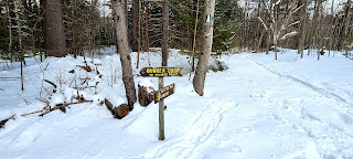
this says Hall Mountain Trail on the sign, but the map shows it as Hall Mountain Marsh Trail here

bikes on Hall Mountain marsh


water crossing on Hall Mountain Marsh Trail

view from Podunk Ledges

Hall Mountain Marsh Trail off Podunk Road