I have the most hikes left in the Monadnock and Cardigan areas. I've always been intimidated with the vastness and technicality of the trails in these areas and had been putting them off. It's getting down to the wire, and I'm trying to save the trails that will be more accessible in Winter.. which means it's time to tackle Cardigan and Monadnock. I headed for Monadnock today with the goal of knocking out some of the side connector trails on the Halfway House side of the mountain. I've done a few of the lower ones, today I would do some of the higher ones. I made my reservation for the Halfway House parking lot. This was my first time parking here. It was smaller than I had expected, but there was plenty of room when I arrived around 830am. The cold has finally set in, and I have a new Winter coat I was excited to try out. We had some snow last week, but thankfully most has melted, though I did have my spikes packed just in case they were needed at higher elevations (they were not). I started up the Old Toll Road, which is a 1.1 mile gravel road walk with moderate incline. I found myself getting too hot, so when I reached the Halfway House site, I took off the coat and found just my long sleeve base layer and polar fleece zip up was sufficient. There was little wind today which made a huge difference. My first trail was Fairy Spring Trail. I immediately started down the wrong trail, as the Guide Book says Fairy Spring is off Monte Rosa, when in fact it is off White Arrow Trail. I realized this quickly and backtracked. Fairy Spring Trail climbs moderately then rather steeply for 0.3 miles. There is one small water crossing (Fairy Spring) then some mossy, rock scrambling. Before I knew it, I was at the Monte Rosa/Smith Bypass intersection. I turned right and then immediately right again, following the yellow blazes onto Smith Bypass. This climbs 0.1 miles and becomes more of a ledgey/slab climb up to the Smith Summit Trail at a big rock that I think is called the Incisor (though to me it looked much more like a whale!) The first views of the day opened up here. I continued a couple tenths up Smith Summit Trail, which was now all rock slab (I like this kind of trail) to the Amphitheatre intersection which was marked with "To Black Precipice" painted on the rock. Amphitheatre started in the woods then opened up at Black Precipice onto a super steep rock slab. I didn't realize at the time that's what it was, I was just trying not to get too scared by the sheer drop off to my right. Amphitheatre continued over some more steep rock slab and came to an intersection with White Arrow Trail. I looked down White Arrow Trail, which I had planned for a second loop and wondered if I had it in me to do another climb.. but pushed that thought aside for the moment and scrambled my way down to Smith Connecting Trail and Sidefoot Trail. I was in and out of the trees and the views were amazing when it opened up. I was initially a bit nervous about going down Sidefoot Trail as I had seen an old comment one time where the poster called it "Slidefoot Trail" but I didn't find it too bad overall. It was steep, but not nearly as overwhelmingly so as I had anticipated. As I descended, and feeling really good overall still, I started to wonder if a second loop was a good idea. I didn't want to get too worn out and put myself in danger on another steep descent. I kept debating with myself the entire time on whether to continue with my plan or return to the car and come back another day. Once back at the Halfway House site, I decided to push on. I started up White Arrow Trail and immediately my legs started to tell me this maybe wasn't a great idea. There were a lot (A LOT) of rock steps.. which are helpful, but also very tiring.. before turning into a full on rock scramble that got steeper and steeper. I contemplated turning around, but my mind won out and I continued. As I got higher there was a little more ice than I had seen anywhere else on the trail, but with careful foot placement it was avoidable. I made it back to the intersection with Amphitheatre Trail and exhaled knowing it was all downhill from here... or so I thought.. and being oblivious to the type of downhill that was coming! I retraced my steps to Smith Connecting Trail, this time passing by Sidefoot and continuing on towards Bald Rock. From here it was some of the gnarliest, steepest descent I've done in a really long while. Lots of butt sliding because by now my legs were toast and I was afraid of falling.. and quite honestly, a lot of it was steeper and taller than I could have walked anyway.. if I wasn't butt sliding, I was grabbing onto trees and hoping they would hold me as I skooched down. I popped out of the woods and was at the base of the climb up Bald Rock. It looked worse than it was and I was bathed in some glorious sunlight that distracted from the climb. At the top of Bald Rock I stopped and enjoyed the 360 degree views, including a low flying small plane as well as the little bitty people over on the actual Monadnock summit. I got a bit confused leaving Bald Rock, but with my digital map I finally saw the trail marker painted on the rock and continued on Cliff Walk a couple more tenths to the Noble Trail intersection. I didn't see a sign here, but luckily saw Noble Trail painted on the rock (also with the aid of my digital map to help me out). Noble Trail started out as rock slab, rather steep descent before re-entering the woods and being a short but really step climb down. I did lose the trail briefly once as there were no blazes that I could see. For the most part it was easy to follow, it was just at a right hand turn that I got a bit off track, but was able to regroup quickly without any drama. Back at Sidefoot Trail, I was so glad to be off the worst of the steepness. On to the Toll Road and I was able to pick up my pace back to the car. 6 miles exactly and just over 1900ft of gain is the most gain I've done in a long while! I was proud of myself for pushing through some tough terrain for me with no incidents or accidents!
Strava Activity
 |
| Old Toll Road |
 |
| Old Toll Road where it leaves the "road" |
 |
| Halfway House site |
 |
| Fairy Spring Trail off White Arrow |
 |
| Fassetts Mountain House site |
 |
| the actual "Fairy Spring" |
 |
| starting to get a bit scrambly |
 |
| Smith Bypass and Smith Summit intersection |
 |
| I believe this is the Incisor.. or a whale to me! |
 |
| turning onto Amphitheatre Trail |
 |
| Black Precipice |
 |
| looking over to Bald Rock from Amphitheatre Trail |
 |
| looking back up some steep slab I had just descended |
 |
| at the White Arrow intersection |
 |
| turning onto Sidefoot Trail |
 |
| now up White Arrow |
 |
| so.many.steps |
 |
| then it just turned rocky |
 |
| then rocky and steep |
 |
| looking back down what I had just climbed up |
 |
| onto Smith Connecting Trail |
 |
| Monadnock summit from the base of Bald Rock |
 |
| the climb up to Bald Rock |
 |
| zoomed in on all the people on the summit |
 |
| onto Cliff Walk |
 |
| crazy steep climb (I had just descended) |
 |
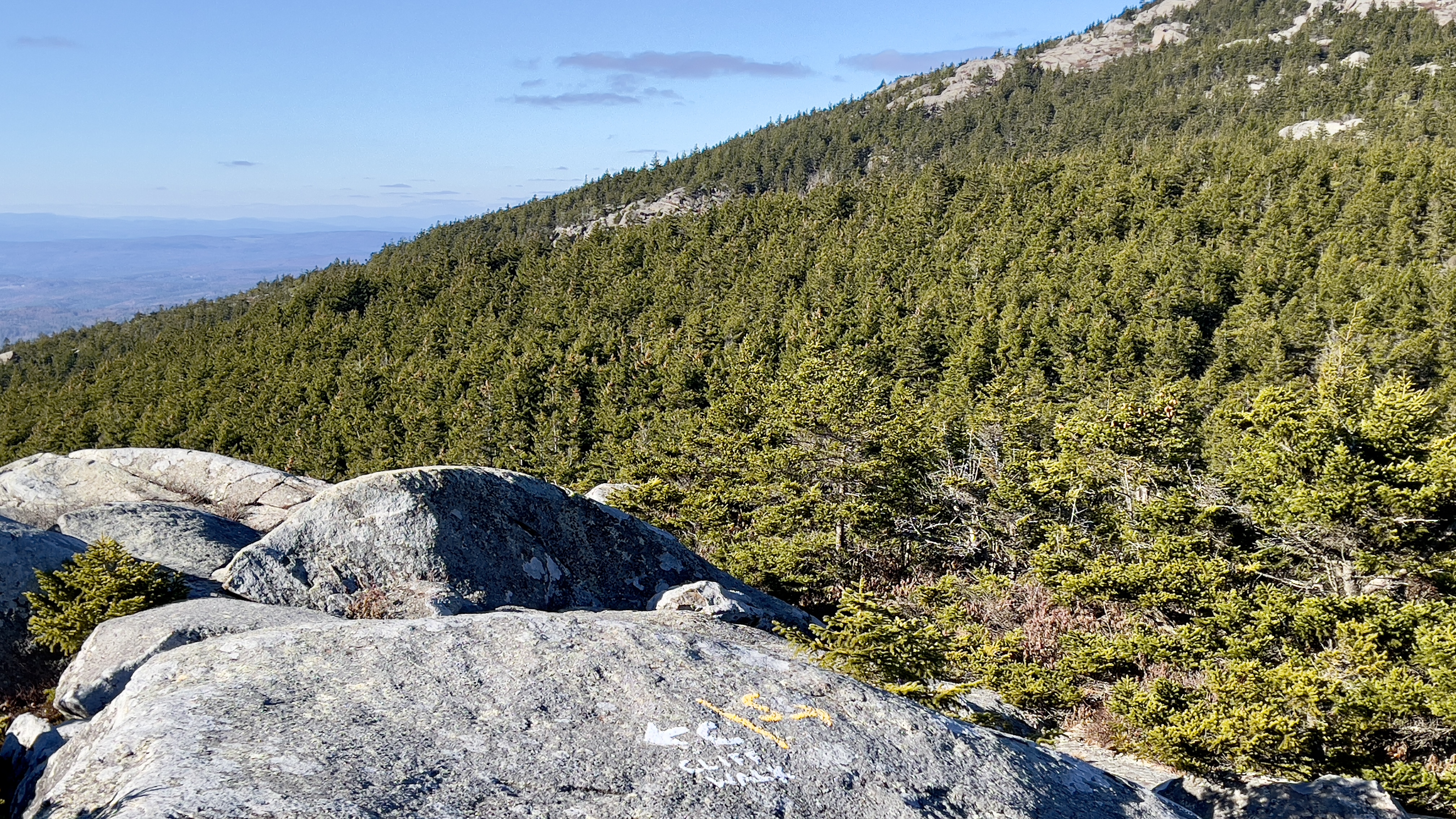
| Noble Trail intersection |
 |
| looking up what I had descended. So steep! |
 |
| Noble Trail intersection off Sidefoot Trail |