Sunday, November 5, 2023

Firescrew & Cardigan via Mowglis Trail

 I was blessed again with my bestie as company and for her driving 2 hours to give us a car spot. I am starting to become more comfortable with the Cardigan back country trails the more I explore them. We spotted a car at the Cardigan State Park main lot, which not surprisingly was already starting to fill. We saw some mountain/downhill bikers which amazed me as this is not easy terrain. Even more surprising was seeing their tire tracks in the col between Firescrew and Cardigan later in the day. I have followed professional MTB/Downhill riding for years, so I know they're hardy folks.. but wow, that is some riding in this area! We drove just a couple miles around the corner to begin at Orange Cove Trail at the end of New Colony Road. There is a fenced off area marked private, but room for maybe 3 cars to the right of the gated entrance to the private area. We parked and geared up, heading up Orange Cove Trail. The entire length is Class VI road/snowmobile trail that has been graded in the past few years.. it had good footing and some easily avoidable mud. The trail/road climbs about 450ft in 1.6 miles so it's a moderate climb, but a good way to get the juices flowing. Nothing scenic except a beaver pond about a mile in with views over to Firescrew and Cardigan beyond. At the end of Orange Cove Trail is a large clearing. The road continues but is now Mowglis Trail. We were picking up Mowglis Trail here and heading into the woods. The trail is marked with a small cairn and "Trail" sign. Just beyond this we saw a water cache with an axe.. maybe dropped by the mountain bikers? From here the trail climbs up 0.2 miles, a little more steeply now to meet up with Elwell Trail. We turned right staying on Mowglis Trail and descended slightly before starting the ascent up to Firescrew. The climb begins gently through some gorgeous mossy pine forest. There was some significant mud which we were mostly able to avoid with some careful rock/log hopping. As we gained elevation we started to see some traces of ice as well. It was mostly avoidable with a couple areas of creative tree hugging to keep us upright. We reached Crag Shelter and stopped for a break. Beyond this the climb became even steeper and more technical (scrambley), but was rewarded with some brief flat breaks in between the climbs and the start of some incredible views (looking behind us). The terrain became more slab/ledge and the views became more open. Before we knew it, we were at the Firescrew summit. The wind had picked up and when it was blowing it was chilly, so we didn't linger for too long but did take a moment to soak it all in while it was peaceful and quiet as we could see the summit of Cardigan had quite a few people. The col between Firescrew and Cardigan is one of my favorite areas having been up there a couple times previously. The cone of Cardigan looming ahead and the gorgeous views all around are breathtaking. We stopped for a snack while under the protection of some trees and added a layer knowing it would be even chillier atop Cardigan. The last couple of tenths up to the summit of Cardigan were a lot steeper than I had remembered. I kept thinking about my first time on this trail with my 2 boys who were much younger at the time and tried to remember what it must have felt like going down because every time I looked back it was amazing to me we ever did that! It's a popular trail though and people were coming down as we were heading up. We reached the summit and it was freezing as anticipated... and crowded also as expected, so we really didn't stop long before heading down the other side on West Ridge Trail. Although still steep, it is the more gentle of the 4 trails up to the Cardigan summit. As always, I was amazed at the number of people on the trail in what we considered inappropriate attire and seemingly unprepared. The trail was wet and muddy in places and thankfully little to no ice on this side. It was leafy as we neared the bottom of the trail, but nowhere near as slippery as last week on Pack Monadnock which made the descent a lot more enjoyable. Back at the parking lot we were met with cars all the way down the access road and thanked ourselves for the early arrival time and good parking spot in the lot!

Strava Activity

I was surprised to see these along New Colony Road

I think they're pointing to the jobsite marked Private. Orange Cove Trail starts at this intersection

along Orange Cove Trail

turning onto Mowglis Trail

water/axe cache on Mowglis Trail

Mowglis/Elwell intersection

some of the gorgeous pines

Crag Shelter

Winter is coming

.. or maybe it's already here

first views


from Firescrew looking at Cardigan


looking back at Firescrew

Cardigan firetower under renovation

looking at Skyland Trail ridge

heading down West Ridge Trail

watch out for bears!


Sunday, October 29, 2023

Pack Monadnock - Raymond Trail

 I had 4 trails left in the entire Wapack Area, and had been putting them off as I know it's a busy area, and I prefer it more quiet. However, redlining doesn't allow for what we like and don't like ;) It was forecast to be unseasonably warm (80 degrees at the end of October!) so Laura and I headed out. We planned a car spot at Miller State Park, beginning at the Raymond Trail on East Mountain Rd in Peterborough. I made my reservation the night before and we attempted to get there as early as possible to beat the majority of the crowds. Raymond Trailhead has room for 3 cars and a couple more roadside if parked smartly. It was a gorgeous morning with the light filtering through the trees making the leaves glow. A car pulled up besides us as we were gearing up and a man got out, not seemingly prepared or really knowing where he was and started out very slowly along the trail. He made us feel very uneasy, so we decided to walk down the road to the overflow parking at Cranberry Meadow trailhead and take the side path up to the Raymond Trail hoping not to bump into him again (we didn't). The sign says 0.5 miles to the additional parking, but it was more like 0.2 and we were on our way. It was muddy down low, but nothing too crazy. We rejoined Raymond Trail after about 0.3 miles and a gentle ascent. The trail basically climbs the entire way with a couple short reprieves. Some of it was on the gentler side, some was quite steep and rocky. It was very, very leafy (being Fall and all) and the leaves were dry for the most part, so in some places it was quite slippery which slowed us down a lot more than anticipated. The terrain was a mix of roots, pine needle bed and big rocks to climb over! All the variety. It was very pretty and definitely the more quieter way to ascend this mountain. We only saw 1 person on our way up. At about 1.6 miles, Raymond Trail crosses the Wapack Trail and continues a few hundred feet to another branch of the Wapack Trail where people were hawk watching. I feel like this has been happening every time I've visited this mountain! We took a left on the Wapack Trail and started the Summit Loop Trail, marked with red dots. We got a bit confused where it left Wapack as there was no sign but if you look carefully there are red dots on the rock ledge, and then where the trail branches off to the right you can see a dot on a tree a little way down. This trail was a little more rugged than I had anticipated (thinking it was advertised as an easy loop for those who may have driven up the auto road to follow). We followed around with some peekaboo views through the trees till we reached the auto road junction and "Boston View" signage. The views today were very hazy, and the skyline was not visible. We picked up Spruce Knoll Trail which takes you 0.3 miles out over a knob (and the town of Temple highpoint) to a bit more of an open view in the same direction as the "Boston View". We backtracked to the auto road and crossed around to finish up Summit Loop which descended down to the Wapack Trail and back up to the Raymond Trail intersection. We crossed back over the summit to Marion Davis Trail, which begins just next to the store. The first half of this trail was very steep and rocky and particularly slippery and somewhat wet as well, which made footing sometimes of a challenge. Even on the less steep sections, all the leaves hid holes, rocks and roots. This trail was VERY busy, as I anticipated. And as always, I was amazed at the amount of people seemingly unprepared. Yes, it may only be a little under 1.5 miles, but the trail is far from easy. I don't know why it still surprises me to see so many people like this! We made it down safely, picking up my car at the Miller State entrance and drove back around to Raymond Trail to pick up Laura's car. That's a wrap on the Wapack Trail. Overall, I loved this whole area, some of my favorite trail sections to date!

Strava Activity

Raymond Trailhead

Cranberry Meadow Trailhead

where the side path from Cranberry Meadow rejoins Raymond Trail

some of the terrain on Raymond Trail

some steep climbs up rocks as well

where Raymond Trail crossed the Wapack Trail

Summit Loop Trail


the "Boston View"

Spruce Knoll Trail from the Boston View


finishing Summit Loop


hawk watching

looking over at North Pack from the summit


so many leaves


Sunday, October 22, 2023

Pisgah State Park - Hinsdale Trail

 Hitting a notoriously wet trail the day after a lot of rain was probably not the smartest idea, but it's done, and I'm no worse for the wear ;) I headed to Pisgah to pick up one of the last 3 trails I have left in this park. My last time having to drive in to one of the interior parking lots. Reservoir Road seems to be rougher each time I drive on it, thankfully it's only just over a mile long. There was already a car there when I arrived, but I never saw anyone while out. I geared up and headed up the gated section of Reservoir Road that climbs a short, steep, partly paved hill. I'm never ready for a steep climb right off the bat, so I took lots of breather breaks, and soaked in the Fall Foliage glory around me. The ground was wet and I was a bit concerned it would be slippery with all the leaves down, but I had no issues. A group of 4 ATVs passed me on my ascent. I made it to the top and took the left at the fork towards Hinsdale Trail. Primarily a snowmobile trail (if there is ever enough snow to open it), it is currently closed to motorized vehicle traffic, but like Dogwood Swamp Trail, park manager Kim had told me it was open to hikers, with the understanding it was likely very wet and muddy. Not long after starting, there is a fork. The right branch is gated and leads a short ways to a wonderful spot on the shores of the reservoir. The trail continues over a spillway, which the AMC South Guide cautions to avoid if the water is high.. which it was, so I did. The spillway bypass is the left branch of the fork and was my first (but definitely not last) encounter with major mud. It skirts around and down then back up slightly to the other side of the spillway and another lovely view over the reservoir. From here the trail crosses the top of a dam before continuing into the woods and out to the park boundary. There were no significant spots along the trail with views or anything to see, but on the brief portions of dry trail, I can see why some have said it was one of their favorite trails in the park (including park manager Kim). Very lightly traveled, since it doesn't actually go anywhere and you have to double back, there is a remote and somewhat enchanted feel about it.. particularly at this time of year with the golden yellows and on this day with the overcast atmosphere, the colors were popping. There were a couple of sections with flagged bypasses of particularly flooded areas, which were easy enough to follow if not completely broken in yet. I remember Kim telling me there were 12 bridges along this trail, so I was counting.. and there were in fact 12! Some were very short, but there were 12 nonetheless. A key clue to how wet this area actually is. Just over 1.5 miles from the start of Hinsdale Trail, there is an unmarked T-intersection (there was some orange flagging tape but no signs). Despite all the no ATV signs, the group of 4 who had passed me earlier, were heading back. I later wondered if they were in fact Friends of Pisgah volunteers scouting the trail because upon my return at the very start of the trail was now a very definite "Closed" sign in place in the middle of the trail. I took the left branch of the intersection first and headed out 0.8 miles to the park boundary. Although the AMC South Guide does describe the trail as going all the way to Rt 63, Kim had advised me that at the park boundary, where the private land starts, the "bridge" is in fact an old truck bed which he felt was not safe enough to go over and really would prefer hikers didn't (even though the land beyond is not under his jurisdiction). I heeded his advice, and called that the end of the of trail. I could see the truck bed bridge that Kim had told me about and beyond that was a cabin, so honestly I was happy to call that done. I backtracked to the T-intersection and this time headed straight on a spur that leads about half a mile to another lovely view over the reservoir. I enjoyed a few moments of solitude there before retracing my steps all the way back to the car! I passed another ATV and dirt bike as I was descending Reservoir Rd, otherwise I saw no one else all day! Just 2 more trails/1 hike and I will be done with Pisgah State Park!

Strava Activity

Reservoir Road driving in

bottom of Reservoir Road heading up

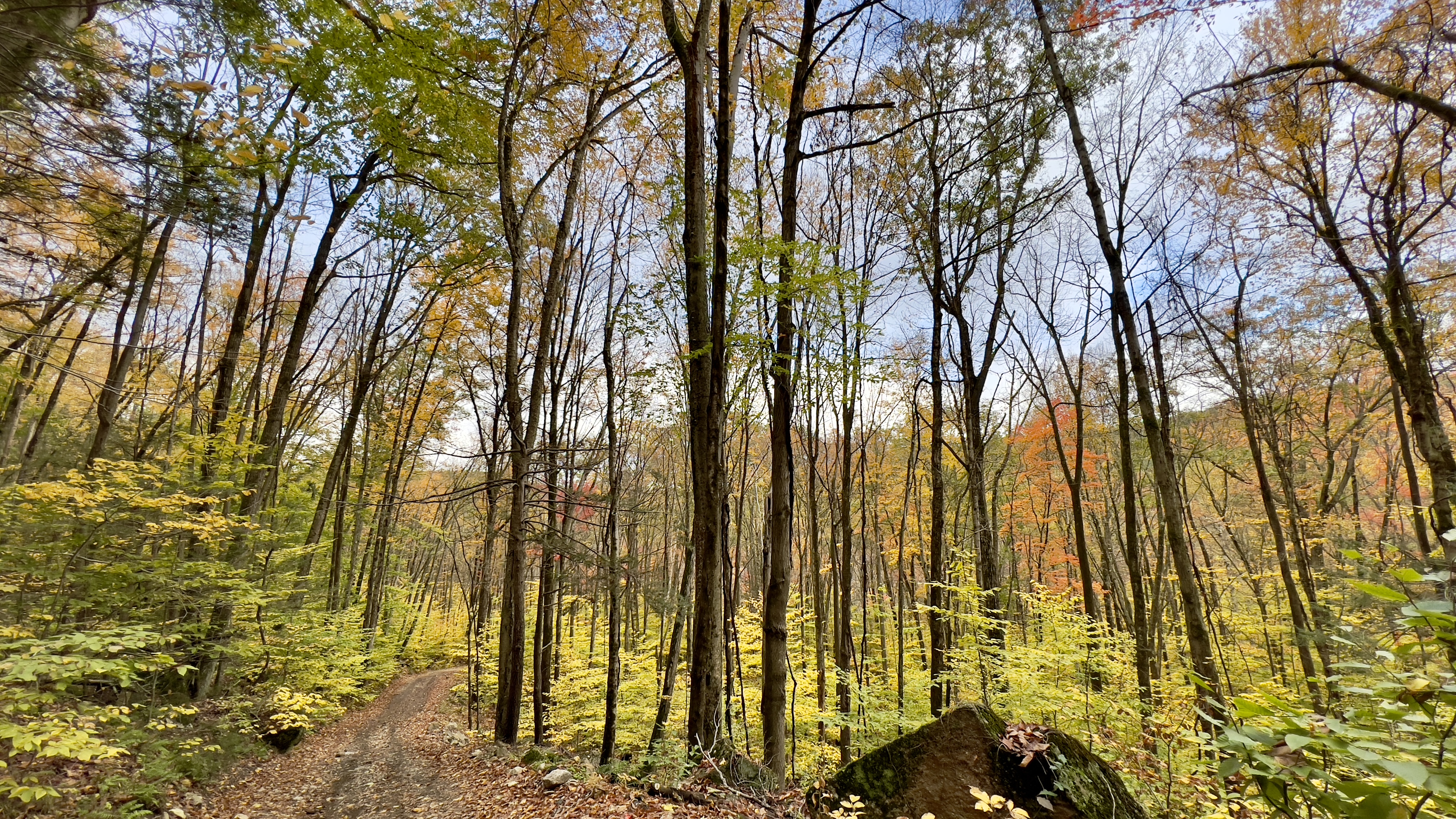
Hinsdale Trail off Reservoir Road

the overflowing spillway I did NOT cross


one of 12 bridges on this trail

looking back at the spillway from the other side


it was wet

which side is the trail ;)


my turnaround point at the park boundary


the t-intersection

along the spur to the reservoir


sign that appeared at the trail start while I was out on the trail

not seen: how steep this road actually is

always so grateful to see my car after a long hike!