Saturday, March 28, 2020

Mine Hill & Jeremy Hill

The weekly airing of the teenagers resulted in two fairly short but pleasant walks to reach two more sites on the NH Fire Tower list. First we hit up Mine Hill in Auburn, NH. There is a small area to park alongside Lake Massabesic on Rt 121 (Chester Road) in Auburn, directly across from Fire Road 42, which is the access road taken for this fire tower. I had printed out another description, which I'm glad I did, and even still we managed to get off course briefly. Very quickly after beginning this walk you will encounter an open area. Stay to the right and follow the old access road. You will come to what I'll call a Y intersection that at the time we walked had a small log in the middle and some pink flagging tape on a tree just to the right of the intersection. We headed down this way and encountered a firepit and thankfully friendly homeowner who redirected us in the correct direction. Therefore, once you reach this intersection, keep left and continue uphill. Shortly after you will encounter another intersection, this time with Private Property signs clearly marked ahead. Keep to the right at this one and head uphill to the end of the old access road. There is a very old, very mossy wooden staircase that leads up a steep, short incline. Here you will see a private residence "uncomfortably close" as I had read. Even knowing ahead of time the house would be there, I was taken aback at how "uncomfortably close" it actually was. Clearly marked however where their property line is, it's easy to stay on the public side and make your way to the summit and cement fire tower footings. Some peekaboo views out to Lake Massabesic is about all there is to see up here.

My Strava app recorded some wacky tracks today on both walks, but I'll post for posterity. I'm one of those "if you don't record it, it didn't happen" people!

Strava Activity
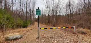


the gate we started/ended

Lake Massabesic


Then we headed over to Jeremy Hill in Pelham. Again, I'm glad I printed out directions, and we still managed to start down the wrong trail! Park in the cul de sac at the very end of Jeremy Hill Road. There is an obvious place to pull off to the right of the circle, that is clear of all driveways. Do not head down the unmarked chained path to the left of the circle, instead look to your right and you will see an actual gated pathway a little ways behind some brush. This is the pathway you want to take. A private pond will be to your left. Head in a little ways and take a left into Jeremy Hill State Forest and up to the summit. There is a lollipop loop around the actual summit which again has some cement footings from the previously standing fire tower. No views or anything exciting to see, but it was a nice stroll (once we found the right way) and we are able to check off 2 more fire towers on the list.

Again, Strava recorded some whacked out pathways for us, which we didn't take, but in there somewhere is the actual path taken.

Strava Activity


This is the incorrect pathway to take...

This is the correct pathway hidden behind some brush


Sunday, March 22, 2020

Bear Hill

Another perfect day to get out and explore during this time of social distancing and self isolation. As devastated as I am for the world and its current state, I'm blessed that my family is well and has been accompanying me on these adventures. Today we headed for Bear Book State Park in Allenstown. Ironically, my husband and I had just watched an episode of 'Dateline' the day before about a horrific series of events that took place in this park over the past 40 years or so involving a serial killer. We reflected somewhat as we walked on this beautiful day about the sadness involving that story and the families affected.

Our destination was Bear Hill. A small "mountain" in the park that is on the NH Firetower list. Being March, the gates to the park are still closed (although we found them open upon our return and encountered a couple of out of state cars who had meandered down the road, I suspect following GPS directions. Not sure why the gate was open and if they were able to drive all the way through!).. we parked in the hiker/biker lot at the gates on Podunk Road. The lot was full, not surprising on this gorgeous day. Amazingly though, on our 2 hour, 4.5 mile hike, we only encountered a couple of mountain bikers, a group of horse riders and a team of sled dogs training with an ATV! That was quite the sight!

We walked down Podunk Road until we reached Bear Hill Trail. From here it is 1.2 miles to the summit, an easy hike. Relatively flat until the final small stretch, and even here the grades are minimal. There are no views really anywhere along this trail. Just a matter of enjoying nature. Just below the summit are the foundations of the former fire tower and lots of anthills. Thankfully not active at this time of year! I had planned on continuing to make a loop, per the map I had printed, on Ledge Trail joining up with Hedgehog Trail and back to Podunk Road. Once we were at the summit though, we found no trace of Ledge Trail or any trail continuing at this point. Therefore we just turned around and headed back the way we came. Instead of taking Bear Hill Trail the entire way back, there is a shortcut to Podunk Road not far from the summit, which we took and then just followed the road back to the car.

Suunto Activity


Sunday, March 15, 2020

Beech Hill (Keene)

Wow, it has been such a long time since I've had the opportunity to get outside and put some miles on these shoes.. I've re-entered the workforce full time and between that and kid commitments (which I adore) I just haven't had the energy to do more for myself.. silly reasons. Now with the crazy world we find ourselves living in (for future reading, we are surviving through the Covid-19 pandemic). All kids sports and activities have been canceled and everyone is practicing social distancing. Honestly, despite the tragic circumstances for this, I'm loving the opportunity to spend quality time with those I love most. My family. It was a gorgeous day and it was perfect to get out and get some fresh air. Having had little to no real hiking for over a year, I knew it had to be easy. Looking at the Fire Tower list we have very slowly been working on, I chose Beech Hill in Keene. Super quick, just over a mile total with about 120 feet of elevation gain, but that was just what I needed. The "trailhead" is on Chapman Road in Keene, a gated fence to an access road leading to some cell towers. Starting up the access road, you quickly encounter a water tank after which a "trail" heads into the woods and out to Sunset Rock which overlooks downtown Keene. I had seen a variety of GPS routes in which people made a loop from here to the summit and back down. We couldn't really figure out where this occurred (ie - we couldn't see a trail) so we followed an old access road to what we believed was the summit, in which there is an old foundation. I had seen on another hikers YouTube video that this possibly was that built by the former owner who had aspirations of opening an inn up there. Today someone has built a little leafy hideaway, but that's all that remains. We "bushwhacked" over to the cell towers and took the paved road back down.

Strava Activity

Sunset Rock