Saturday, December 31, 2022

New London Conservation Commission - Kidder Cleveland Clough

 Today I was super excited as I was back out with my best friend Laura, who is rehabbing an injury and subsequent surgery from earlier this year. I decided to take her to New London to Kidder Cleveland Clough Trail and Extension, as I knew there was little to no elevation gain. We parked behind the New London Outing Club and made the decision to just wear spikes as the snow looked more icy than deep. You cross a field and the trail goes into the woods. This trail is never far from civilization, weaving around between a few streets in downtown New London. A lot of it is boardwalk, which I'm sure is really pretty in Spring or Summer. Today we had some pretty yucky conditions. The recent warm weather and rains have washed almost all the snow away, leaving a mix of icy/slushy mess. This actually made walking along the boardwalks more tricky than it should have been, I slipped off the sides a couple times.. it was a mixture of high water/mud/ice alongside the boardwalks. The first spur off the main trail is about a quarter mile in and goes out to Spring Ledge Farm. Not really a trail as such, it basically follows the driveway for the farm out to the road. It was a complete muddy mess today, and with the farm being in the off season, there wasn't even anything pretty too look at to redeem itself. We did the out and back and continued on the main trail to a lollipop loop called Spring Ledge Loop. Another scenario, where I'm sure it's pretty in the Spring/Summer, today was just a slog through the woods. Back at the main intersection, I suggested we call it a day since the conditions just weren't fun, but Laura said "we're here, let's just finish it off"! Bless her, being her second real hike in several months. We took the last spur that goes across wetlands out to Pleasant St. This section was almost all boardwalks, and was a real mess with debris from the recent storms. We tried to clear as much as we could. The trees gave way to tall grasses before reaching Pleasant St. We decided to cross Pleasant St and do the Kidder Cleveland Clough Extension, which was basically another loop in the woods connecting Pleasant St to a neighborhood called The Birches. It was a little snowier on this side, but we did fine in our spikes. The loop is just under a mile in length. Back at Pleasant St, we retraced our steps, just as some rain started to fall, back to the car. 

Strava Activity

Behind New London Outing Club is the trailhead

after crossing a field, enter the woods here

not sure what this is/was.. it looks intriguing

slushy boardwalks

the 3 way intersection about a quarter mile in

end of the Spring Ledge Farm spur

on the spur out to Pleasant St was very messy

once out of the woods it was clearer, boardwalks under the snow


the Extension trail is just a loop


not sure what the viewpoint is, but nice memorial spot

Back at the Pleasant St side of Kidder Cleveland Clough Trail


Tuesday, December 27, 2022

New London Conservation Commission - Great Brook, Morgan Hill, Dura Crockett

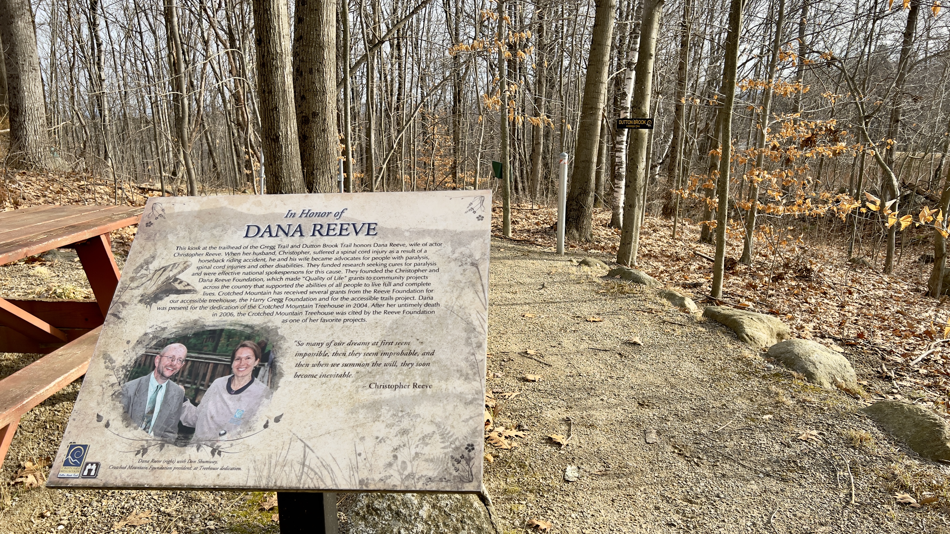
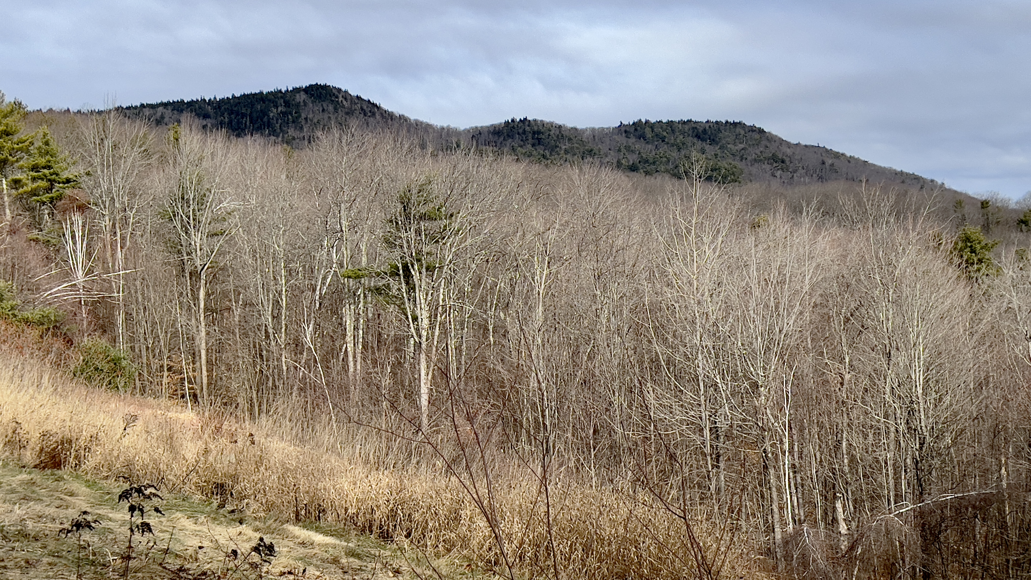
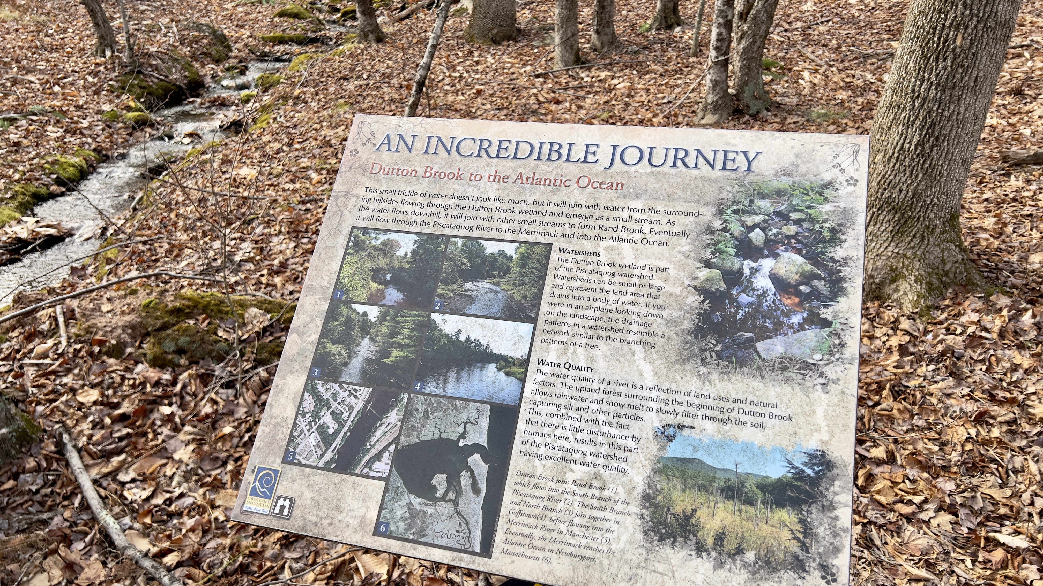
 We had a significant rain/wind storm since all the snow, so I was unsure what the conditions would be like. I headed back to the New London area to tackle a few more trails and was met with plenty of snow still. I parked on Pingree Road, there is a trail entrance marked on a fence with a pullout that will fit a couple of cars. I geared up in snowshoes to start but packed my spikes just in case. The Pingree Connector takes you to Great Brook Trail. I was pleasantly surprised at a well packed snowshoe trail and prematurely got excited that the entire hike would be under such great conditions. I took a left onto Great Brook Trail, having done the section to the right on a previous hike of Bunker Hill Loop. The trail crossed a power line swath and followed Great Brook through the woods. I passed the Lower Cascades, which were spectacular in their frozen glory. The entire brook was so pretty I could have taken millions of pictures of all the ice formations. A fireplace from an old homestead was in the middle of the trail at one point before crossing a bridge and soon after taking a right onto an old road. This section of trail was a combination of ice and frozen leaves, so I opted to remove the snowshoes and put on spikes. Still trying to find my coordination in snowshoes, the spikes were a welcome respite and allowed me to quicken my pace slightly. I reached the Dura Crockett intersection but stayed on Great Brook, noting this as my return point. From here on Great Brook Trail, the clear sections decreased, and while the trail had been broken out, it was less traveled and became more of a slog. Remembering my last time in this area over the Summer, I was anticipating having to reach a clearing with an access road to turn onto Morgan Hill Trail, so I was surprised to find a trail head sign a little ways before the clearing, and realized I had gone slightly off course over the Summer to begin Morgan Hill Trail. I continued the few hundred yards to the access road to officially complete Great Brook Trail and backtracked to the Morgan Hill Trail sign. The few tracks I had been following had continued on Great Brook Trail, but Morgan Hill Trail was completely unbroken. I started in and felt badly for post holing in sometimes knee deep snow, but knew I couldn't put my snowshoes on in such deep conditions, and hoped there would be a large rock or branch sometime soon where I could change. There was a bridge and area that had melted, so I took the opportunity to change back into snowshoes and proceeded to basically break trail from here. I did see one set of boot marks, but they were only helpful in guiding the way, I was breaking trail and it was tough going. Heading up the incline (which is slight, but felt like Everest) I would take a step and slide back 2. I wanted to quit, but knew that wasn't an option! Finally I reached an area where the trail was melting a bit and there were some more tracks which made the going a little easier. I continued down to the other end of Dura Crockett Trail and contemplated continuing on my original plan of picking up Morgan Hill Loop Trail, which I had opted out of on my last trip in this area for the same exact reason.. I was getting very tired! Knowing the intersection was just a short distance down, I decided to see if it was broken out, and if it was, I'd do it, if not, I'd save it for another day. As it turns out, it was broken out/clear, so I decided to go for it. I changed back into spikes, as I knew I didn't have the energy to continue in snowshoes. The trail ascends to the Morgan Hill summit, also the high point of New London. With no views, I continued down to Kidder Trail. This side of the hill was pretty, but the snow was deeper, and was pretty chopped up with frozen post holes. I reached Kidder Trail and took a left. This returned me to the parking area I had used on my last trip and the beautiful views over to Kearsarge Mountain. From here I took a left and headed back up Morgan Hill Trail to the Dura Crockett Trail. Dura Crockett started out with just one set of boot marks. I knew I couldn't possibly do snowshoes again (I was just too gassed) so continued in my spikes. Thankfully it wasn't too deep, but it was definitely a trudge at this point. Not really paying too much attention to my surroundings, just wanting to be done, I kept my head down and plodded on. I reached a water crossing that had ice on it, and I hoped it would hold me as there really weren't any other options for crossing safely. I tested each step with my poles and safely made it across. From here, the trail was more broken out, it seems people had come that far, probably because from this point back the trail followed the brook again with more beautiful frozen cascades. I was happy because I knew once I got back to Great Brook Trail it would  be clear sailing and broken out trail. There was a lot of debris on the trails from the previous storms, but I was able to step over or duck around the bigger ones without too much hindrance. This really is a pretty area, and I highly recommend the sections along the brook. While having only seen it in Winter, I'm sure it's gorgeous in Summer too if there's enough water flowing along the cascades. 

Strava Activity


Sunday, December 18, 2022

Langenau Forest Trails - New London Conservation Commission

 We had our first big snowstorm of the season this weekend. Many areas saw well over a foot of snow. I knew I'd have to snowshoe, my desire was to find as little as possible, so I wasn't potentially breaking trail in the deep stuff. I did the complete opposite. I headed to Wilmot and the Langenau Forest trails on the New London Conservation Commission trail list. Granite Hill Road was a steep up, but thankfully well plowed and maintained. The trailhead is at the very end of the road, and I found the road was not plowed down to the actual parking area. However, there was a plowed spot for 3 cars opposite the last driveway with a truck already parked, so I assumed it was "Winter parking" for the Langenau Forest and parked myself there also. It was a mild day as far as temps were concerned thankfully, with temps in the 30s and little to no wind. I geared up and headed down the road towards to trailhead. I was grateful for the one set of tracks already broken out, but it was still really tough going. The snow was heavy and wet and made each step a slog. I was honestly ready to turn around after about a tenth of a mile! My initial plan of roughly 6 miles and 4 trails was instantly reduced to 2 trails, and I wasn't sure on the mileage, guessed it was roughly 3. I was now going to do a lollipop. At the beginning of the trail is a beaver pond that was iced over and the sun through the clouds made everything look magical.  I had planned on heading up Langenau Forest Trail to Pleasant Lake High Trail and back on Langenau Brook Trail, but when I got to the split, there was a sign that said "Trail" pointing left and that's the way the broken out tracks went. According to my digital download, Langenau Forest Trail went right here, but I thought maybe it was a little further down, so I continued following the tracks. I realized this was in fact Langenau Brook Trail, which was fine, I kept on going and said a silent prayer that the person ahead of me was doing the same loop I had intended! It was very beautiful, but very tough going. I reached the intersection with Pleasant Lake High Trail, which would be a right turn for the loop, or a left turn for my original plan of 6 miles. Wouldn't you know it, the person ahead went left. I knew I could not possibly do that distance, so I reluctantly turned right and started breaking trail myself. It was more uphill than I had thought (and my original plan would have been coming down instead of going up). There were some pretty views through the trees over Pleasant Lake and even a peakaboo view of Mt Sunapee in the distance. A couple tenths in, I was surprised to see someone coming in the opposite direction and was excited at the prospect of a broken trail the remainder of the way... however as I got closer, I realized he was not wearing snowshoes, just bare boots, so while the trail was broken, his tracks weren't overly helpful in the trail breaking department, but were helpful for wayfinding. The trail is blazed with painted blazes on the trees, and some were very faded or covered in snow.. so I was able to at least follow his tracks and not have to spend excess time looking for the blazes. The rest of the way was just through beautiful snow covered trees. The trail descended to join Webb Forest Trail for a few hundred yards before Langenau Forest Trail branched off. This climbed back up, it felt so much more than my Suunto recorded, I felt like I was climbing Mt Everest! Langenau Forest Trail had a lot more storm debris, trees down and low hanging branches from the heavy snow, particularly near the intersection with Langenau Brook Trail, where I had started.. in fact my snowshoe came off as the snow was so heavy! I started to walk on with just 1 snowshoe, knowing I was near the end.. but it was too difficult, so I put it back on for the last couple tenths before arriving back at the car. It was a very beautiful hike thanks to the Winter Wonderland.. but I was very glad to be done! Only 2.65 miles, that took me almost 3.5 hours!

Strava Activity

end of Winter road maintenance

actual trailhead


peakaboo Sunapee, I see you

so beautiful


intersection of Pleasant Lake High and Webb Forest Trails

intersection of Webb Forest and Langenau Forest Trails


So.Much.Snow


near the Langenau Forest and Langenau Brook intersection

beaver pond near trailhead


Saturday, December 10, 2022

Crotched Mountain - Dutton Brook & Gregg Trail

 I headed over to the Crotched Mountain area after my hike in Antrim, just a 25 minute drive and parked at the parking area for the ADA Accessible Trails. There were a few cars there, with a large group just finishing up. My plan was to check out Dutton Brook and Gregg Trails, the 2 handicap accessible trails in this network. They both start at a picnic area next to the parking with signs explaining the trails, as both have information plaques along the way for points of interest. I chose Dutton Trail first, which is the longer of the 2, it is a lollipop loop. It descends gradually at first, but I kept thinking, if you were pushing a wheelchair, it would be a decent form of exertion on the return! The trail is a combination of graded gravel and raised wooden walkways. I found the graded gravel at this time of year was a bit soft, and I was "post holing" a little bit, so I tried to stay as far to the sides as possible, which seemed a bit firmer. I didn't stop to read all the points of interest, but it was good they are there! The one plaque I did read which I found interesting was as the trail crossed Dutton Brook itself, which is a small little trickle.. it talked about how it eventually joined larger streams and rivers and made its way to the ocean! The lollipop of Dutton Brook Trail was just over 2.5 miles total. Back at the picnic area, I started on Gregg Trail. Immediately you come out in an open area with expansive views across to the Uncananoonucs and Joe English Hill. Gregg Trail was all graded dirt, rather than gravel and wooden walkways. A good steady little descent that switchbacked up the slope to an observation platform. On one of the switchbacks I saw another trail paralleling for a moment. During the couple times I have been in this area before, I've noticed several old roads and unmarked trails, so I figured that was what this was, but then saw a sign where it joined with Shannon Trail and figured I'd check it on my descent, so I stayed on Gregg Trail up to the platform. The view here is lovely across to Monadnock, Skatutakee & Thumb, also Bald Mountain where I was earlier in the day. I started down Shannon Trail and quickly arrived at the sign I had seen earlier, and was surprised that it read Summit Trail. There are an East and West Summit Trail on the other side of this network, but I had never seen it come over this far on any maps. I could see on my digital map that it joined up with Shannon Trail above the observation platform and was only about 0.2 miles in length, so I figured I'd grab it just in case it ever formally appears on a map. That way I won't have to come back for that short piece. Back on Shannon Trail, I followed it back down to the car. All told about 3.5 miles on both trails. 

Strava Activity


first point of interest is this lovely view of Crotched Mt


combination of raised walkways like this

and graded walkways like this


really well maintained trails

with several resting options along the way


not marked on any maps, but I walked it anyway just in case