Sunday, March 26, 2023

Pisgah State Park - John Summers Trail

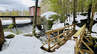
 We had a little more snow this week, but the southwestern area received the least from this latest system, so I headed back to Pisgah hoping to find some decent snowmelt. The answer to that was yes and no. I parked at the Kilburn Trailhead on Rt 63 in Hinsdale and was first car. A NH State Parks truck was ahead of me and a gentleman was gearing up heading out with some maintenance gear. I was later to find out this was Pisgah's sole employee Kim Nelson, who along with some volunteers has been working tirelessly to clean up the park after the Nor'Easter a couple weeks ago that really did some damage. I could see he had no traction on his shoes, but I decided to go with spikes. I bumped into Kim the first time halfway down Kilburn Road as he was clearing limbs from a blowdown and we chatted briefly. Once I reached the intersection with Kilburn Loop Trail, I took a left. Ironically, looking back it was a year to the day that I visited this area the first time. Very different trail conditions then as I look back at pictures of snow free trails! At the intersection for Town Line Trail, I stayed right on Kilburn Loop Trail and headed up towards the Pisgah Ridge Connector, which I needed up to Pisgah Ridge Trail. As I got further into the park, the snow became very mushy (mashed potatoes as I like to call it) and a little deeper, which was tough going in just spikes.. so I did my first traction change into snowshoes, which made going a little easier. Pisgah Ridge Connector climbed gently, then moderately up to the Ridge. No views except over a marsh alongside the trail. The snow was mostly ankle deep and very soft. There was one section where I got a bit confused as the blazes seemed to go up a steep little section with pink flagging, but my digital download showed it continued straight. I followed the pink flagging on my way up. It was quite steep, and I was concerned about descending in the slippery slush, so I decided on my return I'd see if I could follow the lower line showing on the map. I reached my turnaround point and headed back, this time taking the lower line. There were no blazes, but the pathway was obvious until I hit the marsh. The snow was very deep and it was very wet underneath. This makes me think they are rerouting the trail on higher ground. I passed a family on my way back down Pisgah Ridge Connector who had no traction with them at all, but were grateful I had broken a path out. I always carry at least spikes with me until well into Spring. You just never know what conditions you will find! Back at the pond, I took John Summers Trail which is a newer trail and not on all the maps, but is blazed and easy to follow (although I did end up off trail a couple times by making the mistake of following footsteps in the snow!) This is a pretty trail that stays alongside the pond for its entirety. I started to encounter much less snow and even a lot of bare ground, which made me think snowshoes were overkill, so I took them off and bare booted the remainder of the hike. Looking back, spikes would have been a better choice, but I was able to make it with care and quite a few slips! At the bottom of the pond is a bridge over a dam that made for a pretty (and loud) waterfall! I passed a few more groups in this area. I reached the intersection with Kilburn Loop Trail and headed back towards Kilburn Road. The snow had a decent pack for most of it, which in spikes would have been great. Without and with the day warming and the sun coming out, actually made it quite slick. There was also a lot of water on this section of the trail. I encountered Kim again on this portion of trail with another volunteer at another blowdown! I thanked them for their time out, there really is a lot of damage to the park, but so far I haven't encountered anything that has stopped me, just step overs, duck unders or skooch arounds! Back at Kilburn Road and a gentle climb back up to the parking lot and my car. 2 more trails checked off my spreadsheet!

Strava Activity

Kilburn Trailhead

Kilburn Road/Kilburn Loop Trail intersection

Kilburn Loop Trail/Town Line Trail intersection

Kilburn Loop/Pisgah Ridge Connector intersection

John Summers Trail off Kilburn Loop Trail

Kilburn Pond


so.much.water


Saturday, March 18, 2023

SRKG Section 3

 We had a massive Nor'Easter this past week dumping easily over a foot, sometimes 2 feet of snow in most of southern New Hampshire. I was not interested in any way, shape or form of breaking trail in that much snow. I scoured my to-do list of hikes and saw that SRKG Section 3 was 99% roads. This section is roughly 7.3 miles long, so I knew I couldn't do the whole thing as an out and back, so I decided to do half. It was a bluebird day. I parked at the Sunapee Town Office, which has a large lot that was empty being the weekend. I packed my spikes in case the roads were icy, but didn't end up needing them at all. The very start of this section crosses a very short area off road, that was knee deep in snow.. I could see the road the entire time, but being a purist I did stay on the trail and broke this section out. I wasn't worried about post holing as the section was literally just a few hundred feet long. Back on the road, I followed the SRKG white blazes through the center of downtown and onto Lower Main Street. There is a sidewalk on this busier section thankfully. The trail takes a right onto School Street, although there was an SRKG blaze just past this making it seem as if the trail continued straight. I wasn't sure if maybe it had been rerouted and did start to head in that direction, but saw no more blazes.. so I backtracked to School Street and followed that gently uphill to Sunapee Elementary School. I did get a bit confused at the school as I didn't see any blazes, but I had digital tracks downloaded, so relied on that. From the school, the trail climbs uphill to Dowd Lane. Once in the woods past the school, I did come upon a few blazes. This was the only off road section and thankfully it was very short, maybe a tenth or two long. The snow was mostly knee deep, at times hip deep (for me) and was tough going up the hill. It followed a line of trees uncomfortably close to 2 houses. I kept waiting for one of the residents to come out and see me appearing to be stuck in the snow.. thankfully that did not happen, and I made it out to the street unscathed. Dowd Lane is a cul-de-sac, and there were no blazes, but my digital tracks had me head down the street to Sargent Road. Here I saw a blaze pointing to the left on Sargent Road. This was a dirt road and due to the recent snow/warmer temperatures it was very, very muddy. I carefully made my way down this road in order to not slip and slide landing in the mud! This road descended before joining up with North Road and back onto pavement. Climbing up, the trail takes a right onto Hilltop Drive. Back on a dirt road and follows that around before meeting up with North Road again. Here the trail follows North Road, which is a long straight road, but with relentless ups and downs.. some pretty steep ups too, though short. The main thoroughfare for cars turns right onto Trow Hill Road, although North Road continues as a dirt road which I followed until my turnaround point at Seven Springs Road, roughly halfway along SRKG Section 3. Backtracking along North Road I had gorgeous views over to Mt Sunapee. I had decided if I could I would avoid going back through that knee/hip deep snow off Dowd Lane. Looking at my map, I decided to stay on North Road, avoiding Hilltop Lane, and staying on North Road where Sargent Road forked off. This brought me back to Lower Main St, which I followed all the way back to the main intersection where the Town Offices and my car were. Overall, a great day. I don't mind a road walk every now and then. I'll be back to complete section 3 from the other side at a future date. 

Strava Activity

View of start from parking lot


where the off road section popped out from the school

onto North Rd from Sargent Rd

right on Hilltop

back on North Rd

where North Rd turned dirt from pavement

gorgeous views along North Rd

this felt like Everest, it was steep!


relentless hills along North Rd

cows with a view on North Rd

random roadside artifacts along North Rd

the random blaze on Lower Main St about 50 yards past where the trail turned right onto School St


Sunday, March 12, 2023

SRKG - Section 5

 I wanted to go back to New London and finish SRKG Section 5, that I turned around early on a couple weeks ago. We have had a late Winter, but also some warmer days, so I had the wild notion that maybe there had been some snow melt in this area. I parked at the Morgan Hill trailhead and planned on taking the Kidder Trail the 1 mile over to where I needed to pick up the SRKG, figuring that would be well broken out as I know it's a relatively popular area for locals. From the parking, the trail was broken and I just wore spikes, but packed my snowshoes. The snow was soft and mashed potatoey (it's a word) but OK in the spikes. What I was not expecting, was when I reached the intersection with Morgan Hill Loop Trail, the trail was unbroken beyond. Everyone had taken the right onto Morgan Hill Loop Trail and Kidder Trail was waiting for my fresh tracks. I donned my snowshoes and set out. Thankfully Kidder Trail is a relatively mild trail with no real elevation gain and the snow was only a few inches deep. There were only a couple spots that caused me trouble.. one was a bridge I couldn't see under the snow and I stepped in the brook instead of on the bridge.. the second was a really big blowdown I had to get on my hands and knees and crawl under. I was hoping that once I reached the end of Kidder Trail, which is a snowmobile trail, it would be broken out. To my surprise it was completely groomed, which was a real treat for the couple tenths needed to reach the SRKG intersection. What I was not expecting (again) was for the SRKG to be broken and I was completely astonished when I reached the intersection and saw a set of snowshoe tracks down the trail. This lifted my spirits considerably and I headed off for the roughly 1 mile I needed to where I turned around previously. Although not packed down, it was definitely easier than breaking trail completely myself. In parts, the snow was knee deep. Honestly I wouldn't have been able to make it far without these tracks. Also for wayfinding, it's so much easier to just follow someone else's tracks! The trail descended at first, joined another snowmobile trail briefly before turning back into the woods. From here it climbed over an unnamed bump, which was a decent little climb. Then descended before climbing again up towards Royal Arch Hill. This climb was pretty steep, although thankfully only a couple tenths. I reached the point I had been at a couple weeks ago and had no gas to take even 1 more step further! I took a quick break before turning around and retracing my steps. The descent on tired legs and in the snow had me tripping many times and 2 face plants later (within a matter of minutes of each other) I was back down and climbing back over the unnamed bump. Looking at the map, I could see the 2 snowmobile trails converged a little ways past where the SRKG turned back into the woods. Honestly, not wanting any more knee deep snow, I bit the bullet and followed the snowmobile trail down to the intersection and back up to Kidder Trail. It was maybe only a tenth or so longer, but so much easier going on the groomed trail. I followed my own tracks on Kidder and made it back to the car in one piece. That completed my journey on the New London Conservation Commission trails list and I've submitted my checklist to receive the patch! Always about the patch!

Strava Activity

Starting at Kidder Trail on Morgan Hill Rd

that was a crawl under scenario

groomed goodness

amazingly not first tracks on SRKG 5

funky little resting spot


Sunday, March 5, 2023

Pisgah State Park - Doolittle Trail

 Finally a planned Pisgah State Park hike went the way I had hoped! We had a big snowstorm yesterday dumping upwards of a foot + of snow in some areas. I chose Pisgah State Park as I have done in the past, based on it being part of a major snowmobile network with groomed trails. I headed out early and hoped that the trailhead on Chesterfield Rd would be plowed. I had a couple alternate options in my mind in case it wasn't, but was pleasantly surprised to arrive and it find it clear. I parked and geared up in snowshoes. Starting on Old Chesterfield Road, this was groomed, but I also know this is the access point for an active logging operation (having been at this trailhead a few weeks ago) and mentally prepared for the groomed section to only be as far as the trucks needed to drive. I arrived at the Doolittle Trail in about 2/10 of a mile and found it unbroken. I had expected this, as I knew this one wasn't on the grooming network, thus the reason for wearing snowshoes. I had a lollipop loop planned and started on Doolittle knowing it would primarily be downhill in this direction. If I was breaking trail, I'd prefer downhill over uphill! Doolittle Trail connects Old Chesterfield Rd and Broad Brook Rd and meanders around past a pond and through some pretty forest for 1.1 miles. It started snowing while I was on this trail which just added a touch of magic to the morning! Although I broke trail the entire length, it was only 3-4 inches deep thankfully and although not super soft and fluffy, it wasn't hard and crusty either.. it was doable! I did start to get tired towards the end and thought if I arrived at Broad Broad Rd and it wasn't broken, I wasn't sure I could keep breaking trail for more than another mile. If that was the case, I'd double back as I have another hike planned in the future that will involve the entire length of Broad Broad Rd (today I was only doing a 1 mile section). As I was stopped on a bridge over a pond, I heard a snowmobile go past and got excited as I knew that meant Broad Brook Rd would at least be broken out in some capacity. I arrived at the intersection and found it not only broken, but groomed! I kept my snowshoes on, even though spikes would have also sufficed on these groomed sections and was able to move much quicker. The trail/road climbed gently up and past a picnic area to the intersection with Old Chesterfield Road. I was even more pleasantly surprised to find this was also groomed, in fact the entire length of the road was groomed as opposed to Broad Brook which was just the length of a snowmobile itself. I passed the only people I actually saw while out on trail, 4 snowmobiles that had come down Jon Hill Trail onto Old Chesterfield Road. I was also surprised to hear the logging operation working today. I followed this all the way back to my car. Here I was met with 2 more groups of hikers, and an actual logging truck who had stopped to put chains on his wheels before heading into the logging area. A quick, but super pretty wander through the woods!

Strava Activity

Chesterfield Road trailhead

unbroken Doolittle Trail off Old Chesterfield Road

along Doolittle Trail

along Doolittle Trail

along Doolittle Trail

along Doolittle Trail

turning onto Broad Brook Rd

picnic area along Broad Brook Rd

along Broad Brook Rd

some old artifacts along Broad Brook Rd

back on Old Chesterfield Rd back to the car