Sunday, September 29, 2024

Finishing Elwell and Hanging Rocks

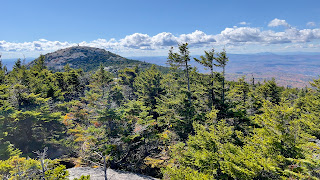
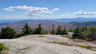
 It was a simply gorgeous day today. I headed back over to the Cardigan area with the intent of finishing everything on the Mowglis Trail side of the mountain. I headed back in to the intersection of Mowglis Trail and New Colony Road. Some sections were a little rougher than I remembered, but we made it with no issue. This week I headed into the woods on Mowglis Trail. Here the trail immediately climbs a little and at roughly a quarter mile intersects with the end of Elwell Trail, which spans roughly 10 miles over to Wellington State Park. I needed the last 0.7 miles or so from this point to the intersection with Back 80 Trail coming up from the Cardigan AMC Lodge. It had rained overnight, so the trail was damp but the sun was shining. I headed down Elwell Trail which was level for a short distance then started a rather steep, but short descent to the Back 80 intersection. The biggest concern was the trail was very leafy, which hid wet rocks and roots. Once, I reached my turnaround point, I retraced my steps back up the now steep ascent. Just near the Mowglis Trail intersection, I saw a herd path heading over to what looked like a clearing so I headed in to see what the views were like. Spectacular views across to Firescrew and the surrounding area. Fall colors were popping. Back to Elwell Trail and I turned left on Mowglis Trail, heading for Firescrew. The first mile is really quite easy with gentle grades and only mild ascents. The trail is really beautiful. And on my way up, I saw no one. Just under half a mile from the intersection with Elwell Trail is a newly marked spur to the Hanging Rocks viewpoint. This viewpoint has existed previously, but not officially marked. I had read there was a new extension of this spur that takes you down and under Hanging Rocks, but I saw no indication of where that might be and since it's not described in the 5th edition of the AMC South Guide that I am working on, I considered it done to reach the viewpoint (as described in the book). Once the 6th edition is published, I can go back and find that new piece. The view was back across to where I had just been on Elwell Trail. More gorgeous colors. I continued on to Firescrew. Initially my plan had been to go up and over Firescrew and find the Grotto Cave spur, however I started much later than I had hoped, and had been taking my time on the climbs. The last quarter mile or so up to the Firescrew summit is quite steep. I was too tired and it was getting too late in the day to continue, so I'll come back and get that another time. Here is where I started to see more people, but thankfully Firescrew is much more quiet than Cardigan so it wasn't an overwhelming crowd. I enjoyed the 360 degree views for a little while before retracing my steps back down Mowglis Trail to the car. 

Strava Activity

Mowglis Trail at the New Colony Rd intersection

end of Elwell Trail at Mowglis Trail

my turnaround point, which completed Elwell Trail 

from the viewpoint just near the Mowglis Trail intersection

Hanging Rocks spur

view from Hanging Rock spur

view from Hanging Rock spur


Mowglis Trail is glorious

views from Firescrew


heading back down Mowglis Trail from Firescrew


views from along Mowglis Trail

driving in on New Colony Road

along New Colony Road


Saturday, September 21, 2024

Wantastiquet-Mondanock Trail - Keene Connector

 Chipping away at this long trail. Per some intel from a fellow hiker, I drove to California Brook Rd in Swanzey to do an out and back on the Wantastiquet-Monadnock Trail. When I arrived initially at the point where the Class VI portion of California Brook Rd begins, I saw some No Trespassing signs that threw me off.. but the more I looked at them, I believe they were referring to the land alongside the road itself, as there was a sign that said "Pass with Caution" and "Unmaintained Road" so I figured they wouldn't have those signs if it was forbidden to access. So I carefully headed down as far as you could drive. For a Class VI road, it was actually in really great shape. A couple rough spots, but nothing compared to some of the Class VI roads I have driven down to access a trail ;) I parked in a small cleared area just before the trail intersection and got myself ready. Once on trail, I needed to do an out and back in each direction, so I headed to my left first. It was about 1.5 miles back to the last place I reached in April, but totally different conditions as it was snowy back then. I was surprised that there was quite a bit more actual trail than I had anticipated, I was expecting a Class VI type road the entire way, and while there was definitely some of that, there was also a lot of trail. It was rather overgrown in some places, but thankfully well blazed so I had no navigation issues. It was very leafy on the trail portion which hid lots of rocks and roots. I really didn't enjoy this section so much, so by the time I reached the small pond I had chosen as my turnaround point in April, I decided I was done for the day. I backtracked to the car and instead of doing an out and back in the other direction, called it a day. Fast forward a week, and I came back to grab the next out and back section. Expecting more of the same from last week, I was pleasantly surprised that this section was much more pleasant. There was still more trail than I had anticipated, but there were no overgrown sections, which just makes Class VI walking so much nicer. I actually went a little further than I had planned as I was enjoying myself so much. Once I reached the Horatio Colony Preserve along Forest Ave (Class VI), I ventured down Bailey Brook Trail for just over half a mile, choosing a random spot that I could easily identify on the map as my turnaround point. There was absolutely nothing of scenic value along this entire section, but I did see 2 porcupines! I have just over 3 miles left in Horatio Colony Preserve to finish the Wantastiquet-Monadock Trail in full. 

Strava Activity

Strava Activity Part 2

This is where I left off on my last visit in the snow!

the Class VI road

friendly little guy

some overgrown trail section

and some really pleasant trail sections

more overgrown stuff

way more "technical" than I had anticipated at some points


thankfully well blazed


approaching California Brook Rd

parking along California Brook Rd

trip 2 from California Brook Rd

so much nicer than last week

right into the woods and alongside some logging


cross a logging swath


entering Horatio Colony Preserve


my turnaround point along Bailey Brook Trail

made more friends on my return


Saturday, September 14, 2024

Mowglis Trail

 I've had the completion of Mowglis Trail on my radar forever.. initially I had wanted to do it as part of a car spot. The descriptions of this trail that I have previously read didn't make it sound overly enticing, so if I could just do it in one direction, that would be great. As it turns out, my car spot buddy has been otherwise occupied for a while.. I miss hiking with her, but life first always. So with options running low as I near the end of this project, and a concern about limited fitness having not been out so much of late, I decided to just go ahead and do an out and back of the 3.5 mile section I needed to complete Mowglis Trail. From what I could gather, parking at the Sculptured Rocks Rd end of the trail was limited, if not non existent. I know you can park at the actual Sculptured Rocks area, but that adds roughly a mile road walk in each direction, which I was not interested in. So I decided to try driving in on New Colony Road all the way to the Mowglis Trail intersection. Having hiked it as Orange Cove Trail last year, I felt this might be doable. Once on the unmaintained section, it was definitely rough in a couple places, but overall not so bad and I was able to get all the way in. The section of Mowglis Trail I would be hiking was a Class VI road for the entire length. Starting at this end effectively means it's downhill first, then uphill back. The road started out somewhat eroded, and I can imagine it would get quite wet and muddy if there had been a lot of rain, but another reason I chose this weekend to hike this was because we haven't had any rain in quite some time.. so although I did encounter some dampness and mud, it was not bad at all. After not near as much erosion as I had expected, the road smoothed out and was more like a dirt or gravel road for the most part. Way better than I had expected! I passed a driveway, which I wasn't expecting and a little further down the road, a man in an ATV passed me by, he must have come from that driveway. He would be the only person I saw all day.. and he passed me again going in the other direction a little while later, perhaps he had gone to check the mail! As the road got closer to the end it followed alongside a relatively dry brook, but it was actually kind of pretty. There were also glimpses through the trees of the ridge up where Elwell Trail is and the Fall colors were starting to pop. Once I reached Sculptured Rocks Rd I just turned around and retraced my steps. The uphill was tougher at this point in the hike and I felt it but overall, this was nowhere near what I had anticipated, and I didn't hate it at all! A really pleasant surprise!

Strava Activity

I parked at the intersection of Mowglis and Orange Cove Trail

started off nice

got a bit muddy

this was the worst of the mud

then was really quite pleasant the rest of the way

passed some snowmobile signage


peekaboo up to the Elwell Trail ridge

started seeing some interesting artifacts

this was actually at the bottom of the driveway


turnaround point at Sculptured Rocks Rd

the eroded section looked a bit more eroded on the uphill

driving out on New Colony Rd looking up at Firescrew