Friday, June 20, 2014
Piper Mountain
A gorgeous day dawned and Beth and I headed back to Gilford to explore Piper Mountain. Having seen the start of the trail from the Carriage Road to Belknap Mountain, I was excited to check another peak off my Belknap Range bucket list. Another one of those bang for your buck hikes, just over a mile to the summit, the trail heads right on up with about 1,000ft of elevation gain. What I love about the summit of Piper Mountain, is it primarily faces in the opposite direction to Lake Winnipesaukee (the traditional Belknap Range view). The actual summit has 2 peaks, North and South which offers a really large open area with lots of corners to peek around. Today we visited the North peak which features a throne someone has constructed from rock! Being a popular summit, it could be crowded.. yet you feel alone in the universe!


Wednesday, June 4, 2014
Roaring Falls Race Preview
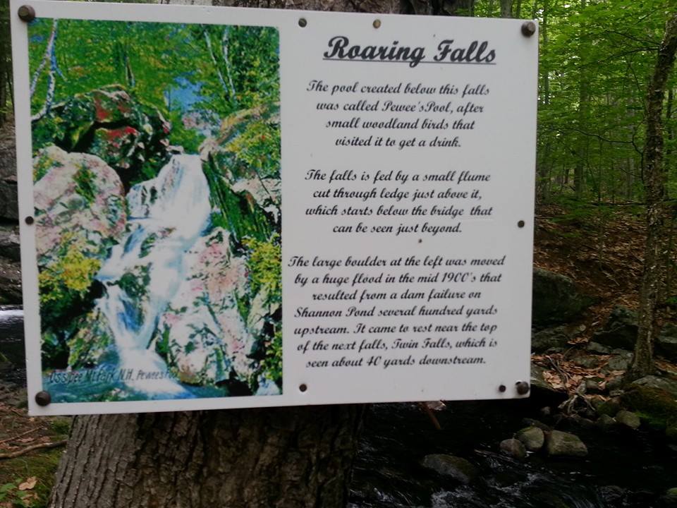
I'm very lucky to have met some outstanding people as part of acidotic RACING. One of those folks is my good friend Robin. She is an incredible athlete.. having competed in running, cycling, triathlons, ironman plus I'm sure many other things. When not training for an upcoming event, I'm blessed to spend many hours traipsing the woods with her. She's a wonderful guide, very patient and most importantly full of encouragement. Robin was putting together a new race on the acidotic RACING calendar on the Castle in the Clouds conservation lands, called the Roaring Falls Trail Race. On this overcast day (with perfect hiking temperatures), I set out with Robin to preview the long course of the Roaring Falls Trail Race which is approximately 11.5 miles long. The end result will be slightly different than we previewed today, but I thoroughly enjoyed my time spent at the Castle and fell in love with the trail system. Extremely well marked (makes me think of a woodsy highway system, with their signs set up like street signs!), the trails are well maintained and in excellent condition. A combination of some technical terrain with lots of wide open carriage roads that carry you up and down without even really realizing it! Best of all, there is a patch you can earn by covering all 19 trails/30 miles which includes 5 summits. Instantly on my to-do list.


 |
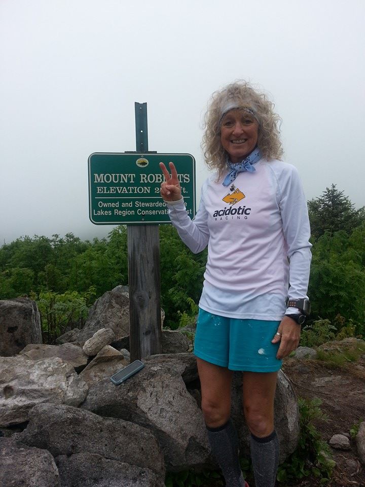
first real viewpoint ascending Mt Roberts
|
 |
| Mt Roberts trail |
 |
Lady Slipper orchid
|
 |
| Mt Roberts Trail |


 |
| looking back at where we had been |
Friday, May 23, 2014
Eastern Belknap Loop
Talk had started amongst some acidotic RACING teammates about doing a Pemi Loop in the Summer. This is a roughly 30+/- mile loop in the Pemigewasset Wilderness. I wanted to do it. But as you can see from my ramblings, I haven't tackled anything even remotely close to that mileage or what would be the elevation gain. So, Spring 2014 is my training ground in the hopes that this dream can become a reality. I coerced Tim into a 10-ish mile hike in the Belknap Range. The Belknap Range Trail traverses the entire ridge from Rowe to Major covering roughly 17 miles. I didn't think I was quite up for that yet, so I researched and discovered a loop over the eastern peaks that would cover roughly 10-11 miles. I felt this was doable. I made plans, I pored over maps, I read every detail I could get my hands on trail reports/descriptions etc. I did everything I could to prepare myself for what would be my longest hike to date. I'm surrounded by a lot of incredible athletes, that do this type of thing in their sleep. It's a big deal for me to undertake these hikes. I'm proud of myself for even making it this far (hence the creation of this blog to remember these moments). The only thing I couldn't control was the weather. *sigh*. Mother Nature wasn't happy today. As Tim had taken the day off work, I felt we should give it a go all the same. We ascended the Brook Trail to the turnoff for Straightback, then took the Quarry Spur trail. I wasn't quite sure where the actual Straightback (North) summit was, I just guessed based on mileage I had read. Tim is super speedy and would go ahead and wait for me at each summit.. I lost trail between Rand and Klem and ended up bushwhacking while panic-yelling (it's a thing) for Tim. He eventually realized I wasn't behind him and came looking for me/heard me yelling and we reconnected. (This sounds dramatic, which is how it felt as my first time ever "off trail".. reality is it was probably 10 minutes total). Thankfully most of the peaks don't really have views anyway, so I felt like we weren't missing too much. By Straightback South we could barely see in front of us due to low cloud and fog. We made it to Major and had planned on descending the Mt Major trail, but being tired and it being wet, I didn't want to risk falling on the steep rock section so we added an extra mile by descending the Brook Trail. The rain and wet conditions slowed us down, and by the end we were soaked, I had extremely sore feet and blisters.. but we did it.


 |
| This is where I guessed on Straightback (North) summit |
 |
| East Quarry |
 |
| East Quarry |
 |
| West Quarry |
 |
| West Quarry |
 |
| Rand |
 |
| Rand |
 |
| Klem |
 |
| Klem |
 |
| Mack |
 |
| Mack |
 |
| Anna |
 |
| Anna |
 |
| Straightback South |
 |
| Straightback South |
 |
| Major |
 |
| Major |


Tuesday, May 13, 2014
Caverly Mountain
Today I headed back up to Caverly Mountain with Beth. It was a dreary, overcast day.. but sometimes those are the best days to just get out there and enjoy whatever Mother Nature throws your way. We ascended via the snowmobile trail. Enjoyed the views. And then discovered a loop trail had been created (or perhaps already existed previously and had been better marked). After some quick contemplation due to a sign stating "Caution: Steep Ledges", we decided to go for it. The ledges aren't so bad, even though I took a slide on the wet rock.. but always good to be aware of what lays ahead. We passed an area of logging which threw us off a bit on the direction of the trail.. but we took a stab and chose correctly. Trail reunites with the snowmobile corridor and back to Kings Mountain Highway where the car was parked. Turned out to be a really nice loop totaling just under 5 miles.


Subscribe to:
Posts (Atom)