Saturday, April 16, 2022

Bear Brook State Park - Ferret Trail

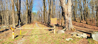
 I had plans to hike somewhere different this weekend but Mother Nature had other ideas. It was forecast to rain starting around lunch time, so I decided to stick closer to home where I knew I could get decent mileage in a shorter amount of time. Back to Bear Brook for my 3rd to last planned hike there. I parked back on Podunk Road, on the Candia side and headed back up just like last week. I continued past Broken Boulder where I was last week and reached Hall Mountain Marsh Trail. The sign says Hall Mountain Trail, but the map says Hall Mountain Marsh Trail, so we'll go with the map. I needed to finish the 0.4 miles or so on this trail, having done the rest a few weeks ago when I went over Hall Mountain itself. This was designed primarily as a mountain bike trail I think, so it's flowy and mostly smooth. At the intersection with the spur over to the Bear Hill cabins, I jumped on that and picked up Ferret Trail. This is a big loop and was wet, muddy and mostly forgettable. It's a snowmobile trail and is wide the entire way and easy to follow. As I approached the bottom of the loop I encountered a former logging area with a clear cut view over to Hall Mountain, which was a nice change of scenery. The bottom section was definitely the wettest and muddiest and took some careful skooching in some places to avoid getting wet. It started to sprinkle while I was on this section, I thought the rains might have been arriving early so got my wet weather gear out, alas it was just a tease.. though I kept my gear on just in case. Once at the bottom, I headed back up the other side of the loop where I had been a couple weeks ago. It became more of a pine bed terrain, which I much prefer than rocky gravel and as the trail neared Bear Hill Pond it became much more pleasant. I saw a spur path with an old fallen down sign that said Bear Hill Pond, so I decided to investigate and this was worth the short detour. The trail is only a few hundred yards and leads to a rocky outcrop at the edge of the pond which on a nice day would be a wonderful spot to set up and enjoy a picnic or snack and sit and enjoy the view of the pond. Even though it was overcast and a rather miserable day, I really enjoyed stopping and just zoning out for a bit. I could see the Bear Hill cabins on the far side, I hadn't realized there were cabins you could rent here at all. I continued on and reached the end at Podunk Road. Taking a right here, I followed the road around and into the area where the cabins are before picking up Hall Mountain Marsh Trail again. I was going to follow Podunk Road all the way back to the car but opted to take the trail, since I had enjoyed it so much a few weeks ago. It looked completely different without the snow/ice but was just as lovely. I ended up hiking just over 8.5 miles and didn't see a single soul until the last few hundred yards when I encountered a local resident out walking. Back at the car and the heavens opened opened just a few minutes after I was packed up and safely inside. 

Strava Activity

Map shows this as Hall Mountain Marsh Trail


view from the clear cut along Ferret Trail


Bear Hill Pond from the spur on Ferret Trail


Hall Mountain Marsh

along Hall Mountain Marsh Trail with the marsh peeking through in the back

view from Podunk Ledges on Hall Mountain Marsh Trail


Sunday, April 10, 2022

Bear Brook State Park - Chipmunk, Bobcat, Broken Boulder

 I don't like to go too far on a Sunday, so back to Bear Brook. I'm going to miss having this so close! Not that I can't go back ever, but there are so many other places to explore! When I first started planning how to tackle all the trails at Bear Brook, it seemed very overwhelming. I pre-planned 12 hikes to get it all done. Today was #9! I really enjoyed today. The weather was ideal for hiking, not hot, not cold, no bugs.. outside of some areas of mud/water the trails were dry and in fantastic shape. That also made for a busy day. Making up for hardly seeing anyone last week, I think I saw everyone twice this week. I parked on Podunk Road in Candia and headed through the gate along Podunk Road, which is a snowmobile trail (as is most of Bear Brook), so wide and easy to follow. I followed for just under a mile and then took a right onto Broken Boulder Trail for just a few hundred yards. I then took a left onto Chipmunk Trail. Chipmunk Trail was split in the middle by Spruce Pond Road. The side I was on first was definitely wetter and muddier, also quieter.. but still pretty. I'm fairly certain the trail was designed as a mountain bike trail as it twisted and weaved it's way through the woods. I crossed Spruce Pond Road and it was much drier. I also saw a lot of people. A group on horseback that were doing some trail maintenance (that is one thing here in Bear Brook you have to look out for on some of the trails, lots of horse poop!), 2 more volunteers were working on building water bars in a particularly wet area. A large group hiking passed by. As I reached Bobcat Trail, I saw some trail runners and pups, then several groups of mountain bikers! I had done Bobcat Trail previously, but today I seemed to fly along it. Much different with no snow/ice on the ground. I reached Broken Boulder Trail in no time and took a right, having come in from the left last time. This section was a little muddier, but still all mostly avoidable. Back at Spruce Pond Road, the trail continues a few hundred yards down to the left past a huge boulder split in two (namesake for the trail, maybe?). As was the case with Chipmunk Trail, this side of the trail was a little wetter and muddier, but I was able to keep my shoes mostly clean and dry. Nothing of scenic note to see, but if you're looking for a really cruisy ramble through the woods, I highly recommend this loop. Ended up being just over 6.5 miles total back to the car. 

Strava Activity


possible namesake for Broken Boulder Trail?


Saturday, April 2, 2022

Bear Brook State Park - Lost Trail

 I was in the mood for a big hike today. The weather, albeit windy, was gorgeous.. perfect for a long adventure. I've had my eye on the Lost Trail loop at Bear Brook for a while. I'd heard conflicting stories on what it was like, whether it was passable or not, so I figured I'd give it a shot. Lots of reports say it can get ambiguous, and I've heard it's swampy with possibly a bridge out. I'd also heard the trail crossed private land, but had permission to do so, but the landowner is often out target shooting. I was prepared for anything. I started at the Hiker/Biker lot on Podunk Road and started down the road to Hayes Farm Trail. I continued past where I had been previously and made it out to Hayes Marsh, which was really pretty. For the next few hours I would see no one! Lost Trail could live up to its name. Most of the trails on this side of the park are part of a snowmobile network so, while not blazed, are easy to follow, wide and relatively flat. All the intersections were marked with signs. I wasn't too far down Lost Trail when I hit the intersection with Lowland Trail. Here I encountered a NH Parks Sign that stated the trail from here on was permanently closed! I could still see a blaze further ahead, but I respected the sign which asked for people to stop trying to reopen the trail and use it. That made all the wondering about whether it was easy to follow or not simple enough! Thankfully I had a map, so I quickly created a new route and headed off down the Lowland Trail. Here I encountered the first real wet sections of the day, but was able to skooch around the edges enough to keep my feet mostly dry. Lowland Trail connected to the other side Lost Trail, which was a wide open snowmobile trail. I took a right here and figured I'd follow as far as I could seeing if there was a closed sign on this side as well. At the bottom of the loop there was another sign the same. I could see a sign further down saying "Bridge Out" also, so some of the prior rumblings seemed to be true. Respecting the wishes of NH Parks, I have eliminated that section of trail from my redlining spreadsheet. Seeing as though I was mentally psyched for a long day out, I decided to continue along Lost Trail to Lost Trail Extension and do an out and back on this trail to get it checked off. At 2 miles each way, it was a little longer than I had anticipated, but it ended up being one of my favourite sections of the day. More snowmobile trail, mostly flat, it just went through a really quiet section of woods with a really pretty marsh/pond/I'm not sure what type of body of water that had all trees coming out of it. It seemed like a painting! I opted to take a section of Ferret Trail back towards my car instead of backtracking on Lost Trail. I'll have to repeat this section as Ferret Trail is a loop in and of itself, but that's OK. It was a gentle climb and quite wet in some places. I took Hedgehog Ledge Trail back over to Hedgehog Trail, which was really the only trail of the day that wasn't also a snowmobile trail. It passed by a boulder section on the side of Bear Hill, which was really cool to pass through. At Hedgehog Trail, I picked up the small section I needed between where I was and Lowland Trail, and double back continuing on Hedgehog Trail (wide snowmobile trail) to Podunk Road. By now I was starting to get really tired. My original itinerary had me picking up Lane Trail to finish off a short section, and looking at the map, that was about half a mile longer than if I just followed Podunk Road straight back to my car. I thought about it briefly and just went for Lane Trail anyway. I knew I'd be glad it was done, regardless of how tired I was. I finished off Lane Trail and was back on Hayes Farm Trail to Podunk Road and back to the car. Just over 13 miles total! One of my longest hikes ever! I've only got 4 more planned hikes and I'll be done with Bear Brook. I've enjoyed exploring what seemed like an impossible task when I first started!

Strava Activity


intersection of Lost Trail & Lowland Trail


along Ferret Trail


Lost Trail Extension

end of Lost Trail Extension to Old Chesterfield Turnpike


Hedgehog Ledge Trail

Hedgehog Ledge Trail


Last section of Lane Trail I needed