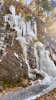
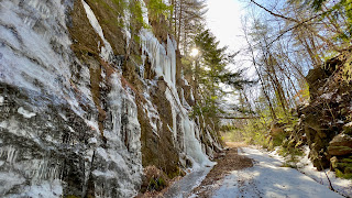
It is unseasonably warm in NH at the moment. 50-60 degrees in February. I am loving it. With zero desire to do anything in snow, Laura and I headed as south as we could and did a loop on the Metacomet-Monadnock Trail. We parked at Rhododendron State Park and walked back out to Rhododendron Road. We wore spikes in the parking lot as it was rather icy. We were able to do the 1.4 mile road walk in just our boots as the sun had melted just about all the ice, and what was left in shadier areas we could carefully avoid. This was a rolling section of small ups and downs, but being on a road, we made good time. We turned right onto Old Troy Road and as we reached the start of the Class VI section we saw signs saying No Trespassing. We wondered if that meant no walking either, but thankfully moments later the homeowner of the last house drove down her driveway and informed us that we were free to continue. She did warn us of some wet sections and we wondered what may lie ahead. The road became more snow covered here, so we opted to put on our spikes for a little more traction. We would keep them on the rest of the way. It is half a mile up Old Troy Road to the Widow Gage Forest Red Trail. We definitely saw the area the homeowner had warned us about as it was very, very muddy with some standing water. Luckily for us, the mud was completely frozen so it didn't give us any problems. We turned left on Red Trail and made a short, steady little climb up and over a knob. Ground cover now, and for the remainder of the hike was a mix of mashed potatoes and leafy bare ground. Hiking in mashed potatoes is exhausting, but I'll take that over breaking trail in knee deep snow. Amazingly, all the trails we hiked today had been broken out since the last snowfall. Although well marked, it did make it easier to just follow the footprints! Roughly half a mile from Old Troy Road, Red Trail meets up with the Metacomet-Monadnock Trail. We turned left and finished the quarter mile that I was too tired to complete a couple weeks ago. We crossed a pretty little brook and turned around at the clearing at Morgan Road. Backtracking, this time we continued straight past the Red Trail intersection and continued back to Old Troy Road. The trail here is both the MM trail and Red Trail, so you'll see both blazes. Turning right back onto Old Troy Road, we were actually glad for the thin snow/ice cover as the road seemed very rough and rocky underneath, but we were able to sail right over. About a tenth of a mile down, at the double blazed tree, turn left back into the woods on Metacomet-Monadnock Trail. Continue for a couple tenths before leaving the Widow Gage Forest and a connector path to Blue Trail and the parking lot for this trail network. Here also marks the end of Metacomet-Monadnock Trail section 3 and starts section 4. For the next mile, the trail climbs steadily up the slopes of Little Monadnock Mountain. I had read in the trail guide that it was steep in sections, which had me nervous.. but what we had been expecting in terms of steep being scrambly and rocky was not in fact the case.. it was great footing the whole way, just a good steady ascent. No views or anything scenic along this section, just a feeling of being far away from anything in the woods. It was a really serene area. We did encounter one gentleman descending as we were ascending and during our brief conversation he told us he has climbed Mt Monadnock 1918 times! Woah! We reached the summit of Little Monadnock and continued over a couple tenths to the intersection with Little Monadnock Trail which connects back to the parking area for Rhododendron State Park. We also saw the only other people of the day at this point enjoying the views over towards Mt Monadnock. This also marked the end of section 4 on the MM Trail and the start of section 5, which I will come back and hike at another time. From here it is about a mile and half to the parking lot and the first half mile is quite steep. The guide describes it as unmaintained and eroded. I had been here a few years ago with Cameron in Summer and did remember some scrambly steep sections so was a bit nervous about descending with the snow/ice. While definitely steep, it wasn't near as bad as I had anticipated. The icy sections could be avoided and with spikes and taking it slow we were able to get down without any trouble. We were really tired at this point, and this section seemed to take forever. We were so happy to see the rhododendrons because that meant we were almost done. I hadn't thought the leaves would hold during Winter on the trees, but they did and the tunnels I remembered were still in tact, which in contrast to the white snow was really beautiful!
Strava Activity
 |
| Laura in the parking lot |
 |
| start of road walk on Rhododendron Road |
 |
| pond along Old Troy Road |
 |
| Turning onto Red Trail in Widow Gage Forest |
 |
| you can hardly see it, but a pole was sticking out of the tree! |
 |
| turning onto Metacomet-Monadnock Trail |
 |
| turnaround point at Morgan Road |
 |
| heading back the way we came from Morgan Road |
 |
| Red Trail and MM merge for a quarter mile or so |
 |
| Right onto Old Troy Road |
 |
| Left off Old Troy Road onto MM Trail |
 |
| End of Section 3 |
 |
| Continuing on Section 4 |
 |
| ridge walking on Little Monadnock |
 |
| intersection with Little Monadnock Trail |
 |
| heading down the steep section on Little Monadnock Trail |
 |
| re-entering the rhododendrons! |


